

Teddy Roosevelt National Park, North Dakota.
The south section of this Park is entered through a town called Medora. It
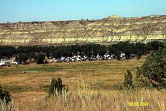 is an unusual name, but one I remember fondly as the first person, the only person, I ever knew with this name was a wonderful lady. Our campsite was right in the Badlands at the entrance of the park. (See pic at right ). We walked from the campsite down to the little Missouri River, which runs through town and through the campsite. I was amazed by the width of the streambed, and the narrowness of the stream in that bed. More than half of the riverbed was made up of chips of rock of many different colors most of which was worn smooth like shells or glass at the ocean. In fact, standing on the riverbed was very much like standing on the beach at the ocean, especially the part of the beach where high tide reaches. Directly across the river where the cliffs that had been worn by the river and were part of a national Park
We took a 36 Mile Drive through the park in a big loop, stopping at intervals for overlooks and special sites. Of course, we stopped for a herd of wild horses, which were l
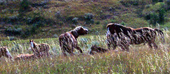 aying in tall grass between the river and the road. In the herd, there was one foal. While we were watching, the stallion rose to his feet, silently opened his mouth wide several times and sauntered off across the field up onto the road. The rest of the herd allowed him to get 20 or 30 yards away and then got up and followed him exactly. That is, they crossed the field, walked up the center of the road a short distance, walked beside the road up to a traffic sign and turned right about 10 feet and then proceeded beside the road, following him, exactly. My first herd of wild horses (called feral horses). (see pic at right)
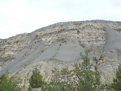
I’ve mentioned before that, I thought I saw a seam of coal running through hills in South Dakota and here again in North Dakota. Well I finally had confirmation. One of the stops we made was for a mile walk along something call the Coal Vein Trail. The Park service has nicely made up a walk with labeled stops and a leaflet explaining the stops. We learned a lot of things on this walk. One of the essentials was that there is a band of coal running through these Badlands. This vein of coal has caught on fire at various times, one of which burned 25 years. The burning coal heats the layers of sediment around the fire, and converts the sedimentary rock to something like metamorphic. In many instances, the heated layers were red in color, and the resulting rock looks like brick. In this Park, this transformed rock is called the scoria. This is a term really related to volcanoes but they use it here for this purpose.
While the visitor center. I found a book on the geology of the high plains, which the Dakotas are part of. Essentially, it explains that the Black Hills are granite, which means they rose from the molten magma. This happened long before the Badlands came to be. The rest of the High Plains were under a low inland sea for millennia. I had always assumed the layers I could see in the Badlands are laid down during this inland sea period. According to this book, those layers are buried deep underground and the layers we can see in the Badlands are result of the rise of the Rocky Mountains to the west of the high plains, which over the centuries have washed down to their granite core. The land washed away from them was deposited by the rivers across the High Plains. Then after the general uplifting of the western half of the plains blocked the flow of the rivers, which then cut the land to reestablish the flow of water. Results, the Badlands of North and South Dakota. Interesting, eh?
Today we went to the Painted Canyon, which is part of the Park, but has a separate entrance. It’s very pretty, but I liked the view from the highest point in the park better. Tomorrow, we visit the North unit. More then.
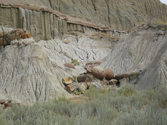
North unit not very different from the South. I did learn about Cannonball Concretions!!
One of the naturally occurring oddities are round rocks, maybe 2 feet in diameter, laying in the surrounding sediment but of a different kind of rock. Look like large cannonballs. (see pic at right ).
Another thing learned is this thing called Bentonite. It is a blue-gray layer of volcanic ash from the Rockies mixed with a clay. When it is exposed to the elements, it appears to run down the cliff faces like frosting on a hot cake. Beautiful. (see a
 t right)
More pics here.
CHAT
I’ve received a criticism from a dear friend about this blog. She says it covers the unimportant stuff found in any travelogue but leaves out the important stuff I call chat. See what you think.
When we left Rapid City, SD, we adventured due to this navigator’s error(s). Yes, I have been made navigator. We had heard that SD Rte 14A was just too beautiful to miss and that an RV could easily drive the route. So we took route 385 to 14A (I left the map in the towed car but “knew” I wouldn’t need it). We went up, and I mean UP, through a town called Lead where the biggest thing is a surface (strip) gold mine on the main street. Thnak god Mike is a very good driver of this large RV. Anyway, at the end of the Main Street, there is a junction with 41A, both left and right. Since we wanted to go North and the compass read West, I yelled turn right. Mike did and we went down as steep and long a hill as we had just climbed. At the bottom was another town which turned out to be Deadwood, one we were to avoid by taking 41A! The navigator had performed a miracle! We had climbed a hill , completed a circle and ended up at the wrong end of 14A. Oh well, we found US Rte 85 which was to lead us all the way to Medora, ND anyway so off we went!! I hope I learned to take the map with me next timed!
We followed rte 85 for hours and hours. I began to count the curves because they were so few and far between. This road is straight as an arrow, 2 lanes and speed limit 65. 6 hours later we got to I 94 which took us the last 15 miles to Medora. Now Medora is a real find!! This is a tourist town with 88 year round residents. The biggest grocery store turns out to be the little bit of food sold at the campground office! We had decided to have steak on Sunday so I thought a tossed salad and garlic bread would be good with it. We shopped the grocery, no luck. Went to the Painted canyou about 5 miles East of town and then I suggested we go 10 miles further East to find a grocery. Not even a camp grocery in Belfield ND (about 30 houses). On Monday we drove to the North unit of TR Park up Route 85. For 40 miles we saw signs for Grassy Butte X miles ahead. I became excited to think of the possibility of a STORE in ND! We drove through Grassy Butte and saw 2, yes two, houses!!
We enjoyed the North unit and on returning I saw a School Bus Stop Ahead sign. I remarked that I didn’t remember seeing such a sign coming North so I counted the School bus Stop signs. In 68 miles, I saw TWO signs. I have never seen such unsettled or undeveloped country. Miles and miles of hay and wheat fields with large pastures in between. Every time I saw a house it was surrounded by trees, the only trees in the whole landscape. I bet we didn’t seen 20 houses in the 68 miles.
So, we leave here on I 94 West tomorrow, heading for Billings MT and beyond. It is raining today and 58 degrees but the heat is on so still in shorts.
Let me know which blog you prefer.
1 comment:
I like the chat! :) I like both, but I want to hear about the fun stuff, the personal stuff, what you had for dinner! :)
Post a Comment