Driving through Montana has been a wonderful experience. It is kept me on my toes and surprised by so much of what I saw. First a few words about North Dakota. I told you about how few and far between the school bus stops were. However, I forgot to tell you about the exits from the interstate and even US highways. More often than not, the exit would say a street, a town or just a road name and at the exit ramp would say," No Services". At first we thought this was funny but as time went on we began to realize no gas, no food, no nothing. While we were in Medora, we attended the" world famous" play which has been going on there for 20 years. It's a musical with North Dakota as its theme, it is rewritten each year so that people who have seen in the past can return. Anyway, it was fun, it was cold, it spoofed "No Services".
Anyway, we left North Dakota yesterday, the 29th, and crossed the Montana border after about 20 miles. As usual, when I cross a border I'm looking for something different. We went miles into Montana and I saw no change. In fact the part of Eastern Montana that I saw was the same as North Dakota. It wasn't until we were 150 or so miles into Montana that I saw the Montana I had imagined. There were lots of flat river bottoms and flat high plateaus with broken rock and high heels off to the sides. I also saw a lot of snow fences. At first, I didn't recognize them for what they were. Imagine two triangles set parallel to each other and across the face of the two triangles are nailed boards about three or 4 inches apart parallel to the ground and going up six to 10 boards. These constructions would be set next week other to form a long fence. But we hear defense, connected to nothing. I finally looked it up on the net and found this is the proper way to build a snow fence. Furthermore, the higher the fence, the higher the drift of snow it creates around it. Since we were traveling the interstate, I assume this is the best defense against closing the road.
We traveled Interstate 94 to Interstate 90 in Billings. Then we traveled 90 West to Bozeman, much of the way we travel through the beautiful Yellowstone River Valley. The river flows north to the Missouri but through most of the distance we traveled along it, it meandered through Oxbow after Oxbow back and forth. If I understand it correctly, this meandering is due to the fact that it is nearly level. That is, there is very little drop in its progress. Anyway it created a thing of the beauty and we crossed it a number of times, much like Interstate 89 does with the White River. The real difference is that the White River valley is quite narrow and the Yellowstone River Valley is very wide and filled with hay fields, wheat fields, and horse ranches. There are some really notable differences in the agriculture practiced in the Yellowstone River Valley. I noticed that the productive fields, hay and wheat, are all irrigated. Furthermore we saw fields being cut today, August 30, and bailed into big round Green bales. Some of the bales were being transported on trailer trucks toward the east.
We stopped in Bozeman at an AAA recommended spot called the Museum of the Rockies. The section of the museum on the geology of the Rocky Mountains was excellent. I really felt I understood the formation of this important feature of our landscape. It was also a King Tut exhibit which was pretty good. Included in the admission price was a presentation in the planetarium on what the Egyptians saw in the night sky and how it related to the way they lived. Did you know that Polaris, our North Star, was not the North Star for the Egyptians. Apparently, unbeknownst to me, the earth has a wobble that moves due north over a 26,000 year period. When the Egyptian civilization was at its height, a much dimmer star was located over the pole. Once you know this, the Egyptian system of aligning temples, pyramids, and other public buildings makes sense.
We drove down Route 191 from Bozeman through the Gallatin Mountains, into Yellowstone Park. The pass through the mountains was very narrow and winding. At the end of the pass, we climbed quite high. As we crested the hill, a huge valley opened before us which was the beginning of the Park. I was totally surprised. Somehow I thought Yellowstone Park was going to be in the mountains. Tomorrow we'll enter through the West gate to see Old Faithful and other things and I will learn what Yellowstone Park is really like.
Thursday, August 30, 2007
Tuesday, August 28, 2007
North Dakota


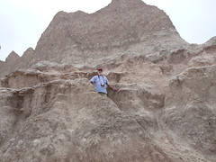
Teddy Roosevelt National Park, North Dakota.
The south section of this Park is entered through a town called Medora. It
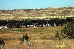 is an unusual name, but one I remember fondly as the first person, the only person, I ever knew with this name was a wonderful lady. Our campsite was right in the Badlands at the entrance of the park. (See pic at right ). We walked from the campsite down to the little Missouri River, which runs through town and through the campsite. I was amazed by the width of the streambed, and the narrowness of the stream in that bed. More than half of the riverbed was made up of chips of rock of many different colors most of which was worn smooth like shells or glass at the ocean. In fact, standing on the riverbed was very much like standing on the beach at the ocean, especially the part of the beach where high tide reaches. Directly across the river where the cliffs that had been worn by the river and were part of a national Park
We took a 36 Mile Drive through the park in a big loop, stopping at intervals for overlooks and special sites. Of course, we stopped for a herd of wild horses, which were l
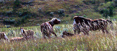 aying in tall grass between the river and the road. In the herd, there was one foal. While we were watching, the stallion rose to his feet, silently opened his mouth wide several times and sauntered off across the field up onto the road. The rest of the herd allowed him to get 20 or 30 yards away and then got up and followed him exactly. That is, they crossed the field, walked up the center of the road a short distance, walked beside the road up to a traffic sign and turned right about 10 feet and then proceeded beside the road, following him, exactly. My first herd of wild horses (called feral horses). (see pic at right)
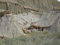
I’ve mentioned before that, I thought I saw a seam of coal running through hills in South Dakota and here again in North Dakota. Well I finally had confirmation. One of the stops we made was for a mile walk along something call the Coal Vein Trail. The Park service has nicely made up a walk with labeled stops and a leaflet explaining the stops. We learned a lot of things on this walk. One of the essentials was that there is a band of coal running through these Badlands. This vein of coal has caught on fire at various times, one of which burned 25 years. The burning coal heats the layers of sediment around the fire, and converts the sedimentary rock to something like metamorphic. In many instances, the heated layers were red in color, and the resulting rock looks like brick. In this Park, this transformed rock is called the scoria. This is a term really related to volcanoes but they use it here for this purpose.
While the visitor center. I found a book on the geology of the high plains, which the Dakotas are part of. Essentially, it explains that the Black Hills are granite, which means they rose from the molten magma. This happened long before the Badlands came to be. The rest of the High Plains were under a low inland sea for millennia. I had always assumed the layers I could see in the Badlands are laid down during this inland sea period. According to this book, those layers are buried deep underground and the layers we can see in the Badlands are result of the rise of the Rocky Mountains to the west of the high plains, which over the centuries have washed down to their granite core. The land washed away from them was deposited by the rivers across the High Plains. Then after the general uplifting of the western half of the plains blocked the flow of the rivers, which then cut the land to reestablish the flow of water. Results, the Badlands of North and South Dakota. Interesting, eh?
Today we went to the Painted Canyon, which is part of the Park, but has a separate entrance. It’s very pretty, but I liked the view from the highest point in the park better. Tomorrow, we visit the North unit. More then.
North unit not very different from the South. I did learn about Cannonball Concretions!!
One of the naturally occurring oddities are round rocks, maybe 2 feet in diameter, laying in the surrounding sediment but of a different kind of rock. Look like large cannonballs. (see pic at right ).
Another thing learned is this thing called Bentonite. It is a blue-gray layer of volcanic ash from the Rockies mixed with a clay. When it is exposed to the elements, it appears to run down the cliff faces like frosting on a hot cake. Beautiful. (see a
 t right)
More pics here.
CHAT
I’ve received a criticism from a dear friend about this blog. She says it covers the unimportant stuff found in any travelogue but leaves out the important stuff I call chat. See what you think.
When we left Rapid City, SD, we adventured due to this navigator’s error(s). Yes, I have been made navigator. We had heard that SD Rte 14A was just too beautiful to miss and that an RV could easily drive the route. So we took route 385 to 14A (I left the map in the towed car but “knew” I wouldn’t need it). We went up, and I mean UP, through a town called Lead where the biggest thing is a surface (strip) gold mine on the main street. Thnak god Mike is a very good driver of this large RV. Anyway, at the end of the Main Street, there is a junction with 41A, both left and right. Since we wanted to go North and the compass read West, I yelled turn right. Mike did and we went down as steep and long a hill as we had just climbed. At the bottom was another town which turned out to be Deadwood, one we were to avoid by taking 41A! The navigator had performed a miracle! We had climbed a hill , completed a circle and ended up at the wrong end of 14A. Oh well, we found US Rte 85 which was to lead us all the way to Medora, ND anyway so off we went!! I hope I learned to take the map with me next timed!
We followed rte 85 for hours and hours. I began to count the curves because they were so few and far between. This road is straight as an arrow, 2 lanes and speed limit 65. 6 hours later we got to I 94 which took us the last 15 miles to Medora. Now Medora is a real find!! This is a tourist town with 88 year round residents. The biggest grocery store turns out to be the little bit of food sold at the campground office! We had decided to have steak on Sunday so I thought a tossed salad and garlic bread would be good with it. We shopped the grocery, no luck. Went to the Painted canyou about 5 miles East of town and then I suggested we go 10 miles further East to find a grocery. Not even a camp grocery in Belfield ND (about 30 houses). On Monday we drove to the North unit of TR Park up Route 85. For 40 miles we saw signs for Grassy Butte X miles ahead. I became excited to think of the possibility of a STORE in ND! We drove through Grassy Butte and saw 2, yes two, houses!!
We enjoyed the North unit and on returning I saw a School Bus Stop Ahead sign. I remarked that I didn’t remember seeing such a sign coming North so I counted the School bus Stop signs. In 68 miles, I saw TWO signs. I have never seen such unsettled or undeveloped country. Miles and miles of hay and wheat fields with large pastures in between. Every time I saw a house it was surrounded by trees, the only trees in the whole landscape. I bet we didn’t seen 20 houses in the 68 miles.
So, we leave here on I 94 West tomorrow, heading for Billings MT and beyond. It is raining today and 58 degrees but the heat is on so still in shorts.
Let me know which blog you prefer.
Thursday, August 23, 2007
Land II (Black Hills)
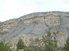
I spent yesterday in the Black Hills of South Dakota. I was prompted by c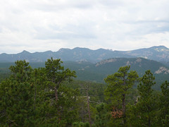 uriosity to ask why they were called the Black Hills. Now there is a little story behind this question. As we entered South Dakota from Minnesota, I saw hills to the north of Interstate 90 with a black streak running through them. That black streak was probably 50 feet high and ran for half a mile. I asked Peggy and Mike, if that is what the Black Hills looked like. They said no. Now that I've seen the Black Hills, I'm pretty sure that what I was seeing was black rock exposed in the construction of Interstate 90. Or maybe it was the vein of coal? The story of the name of the Black Hills as told by natives is when settlers, explorers, arrived at the hills after crossing the barren prairie, the fir covered hills looked black. (see pic at right)
We began the day by traveling south on the Iron Mountain Road. this route goes through part of Custer State Park, where we spent the rest of the day. As we traveled on this torturous hairpin turn road, the huge granite outcroppings, ledges and bolders made me think of Smugglers Notch in Vermont. The road twists and turns around mountains (Hills) which squeeze the traveler from both right and left. Th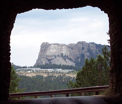 ere were a number of bridges involved in those hairpin turns. They were quite odd. They were called pigtail bridges and were constructed from logs in the form of a three large arches which turn so they weren't in a row. We went through one of the arches on the road, swung around a sharp curve and up over the bridge, turning as we went. Interesting. There were three tunnels carved out of the mountains on this road. After passing through each tunnel, we stopped and looked back at a perfectly framed picture of Mount Rushmore (see pic at right).
Next we took the wildlife loop through the southern half of Custer State Park, where I saw my first wild buffalo (bison) herd. I saw them dotted over a far field, and then on the road in front of us. Shortly thereafter, I saw my first pronghorn antelope. Several times on the loop, we saw wild burros, which are not native to the region, but were released from a tourist trap that failed many years ago. This entire wildlife loop was composed of valleys and dry gullies. The land was not good for agriculture. It was dry and had a lot of stone in it and it was obvious that it had very little rainfall. What rainfall it did have came in heavy rain storms which washed through the gullies and into what I saw as dry streams. In fact, we had heard on TV that there was flooding in the Black Hills just a week prior to our arrival here. I saw evidence of this flooding in a number of the valleys in this park. Lots of tree branches, tree stumps with roots attached, and clay.
I need to take a little detour from the travel narrative here. When I was in the Southwest, I learned, discovered, and that the beauty of the landscape there was really due to massive erosion. Now that I'm in southwestern South Dakota, I can see that the beauty of the landscape here is also due to massive erosion. In the Badlands, you can see the results of years, millennia of erosion. You see the gullies, where the water erosion continues to this day. Here in the Black Hills, you can see much of the same problem. Only here, I think it is earlier in the progression. Major erosion has already taken place here in the Black Hills, but the result is to expose massive slabs of granite which underlies the soil in this area. In Custer State Park, I also saw eroded sandstone, which in some cases appeared to be attached to the granite, like it had been melted together. Today, we were riding north into Rapid City (the second largest city of South Dakota) to do a little shopping, and we started down a hill from a high flat prairie area and I saw in front of me red sandstone or just red soil showing on the grassy hillsides. I suddenly realized that this valley we were driving into was just as eroded as anything I've seen in Custer State Park or even in large parts of the Badlands. The only difference was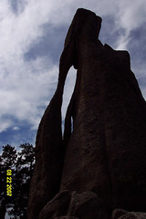 this valley was lightly coated with scrub grasses. In many places the hillsides are so steep that it is naturally terraced, sort of corduroyed. Anyway, I'm shocked again by the awful beauty of destruction.
The last part of our trip was along Needles Highway. This was a great deal like the iron Mountain Road, but the switchbacks were sharper and there were a lot more of them. And we were going down steep hillsides with deep ravines alongside. Again, there were three tunnels, but no views of Mount Rushmore. We did stop after a tunnel to view the natural eye of the needle cut into the rock by erosion (see pic at right).
More pics here.
uriosity to ask why they were called the Black Hills. Now there is a little story behind this question. As we entered South Dakota from Minnesota, I saw hills to the north of Interstate 90 with a black streak running through them. That black streak was probably 50 feet high and ran for half a mile. I asked Peggy and Mike, if that is what the Black Hills looked like. They said no. Now that I've seen the Black Hills, I'm pretty sure that what I was seeing was black rock exposed in the construction of Interstate 90. Or maybe it was the vein of coal? The story of the name of the Black Hills as told by natives is when settlers, explorers, arrived at the hills after crossing the barren prairie, the fir covered hills looked black. (see pic at right)We began the day by traveling south on the Iron Mountain Road. this route goes through part of Custer State Park, where we spent the rest of the day. As we traveled on this torturous hairpin turn road, the huge granite outcroppings, ledges and bolders made me think of Smugglers Notch in Vermont. The road twists and turns around mountains (Hills) which squeeze the traveler from both right and left. Th
ere were a number of bridges involved in those hairpin turns. They were quite odd. They were called pigtail bridges and were constructed from logs in the form of a three large arches which turn so they weren't in a row. We went through one of the arches on the road, swung around a sharp curve and up over the bridge, turning as we went. Interesting. There were three tunnels carved out of the mountains on this road. After passing through each tunnel, we stopped and looked back at a perfectly framed picture of Mount Rushmore (see pic at right).Next we took the wildlife loop through the southern half of Custer State Park, where I saw my first wild buffalo (bison) herd. I saw them dotted over a far field, and then on the road in front of us. Shortly thereafter, I saw my first pronghorn antelope. Several times on the loop, we saw wild burros, which are not native to the region, but were released from a tourist trap that failed many years ago. This entire wildlife loop was composed of valleys and dry gullies. The land was not good for agriculture. It was dry and had a lot of stone in it and it was obvious that it had very little rainfall. What rainfall it did have came in heavy rain storms which washed through the gullies and into what I saw as dry streams. In fact, we had heard on TV that there was flooding in the Black Hills just a week prior to our arrival here. I saw evidence of this flooding in a number of the valleys in this park. Lots of tree branches, tree stumps with roots attached, and clay.
I need to take a little detour from the travel narrative here. When I was in the Southwest, I learned, discovered, and that the beauty of the landscape there was really due to massive erosion. Now that I'm in southwestern South Dakota, I can see that the beauty of the landscape here is also due to massive erosion. In the Badlands, you can see the results of years, millennia of erosion. You see the gullies, where the water erosion continues to this day. Here in the Black Hills, you can see much of the same problem. Only here, I think it is earlier in the progression. Major erosion has already taken place here in the Black Hills, but the result is to expose massive slabs of granite which underlies the soil in this area. In Custer State Park, I also saw eroded sandstone, which in some cases appeared to be attached to the granite, like it had been melted together. Today, we were riding north into Rapid City (the second largest city of South Dakota) to do a little shopping, and we started down a hill from a high flat prairie area and I saw in front of me red sandstone or just red soil showing on the grassy hillsides. I suddenly realized that this valley we were driving into was just as eroded as anything I've seen in Custer State Park or even in large parts of the Badlands. The only difference was
this valley was lightly coated with scrub grasses. In many places the hillsides are so steep that it is naturally terraced, sort of corduroyed. Anyway, I'm shocked again by the awful beauty of destruction.The last part of our trip was along Needles Highway. This was a great deal like the iron Mountain Road, but the switchbacks were sharper and there were a lot more of them. And we were going down steep hillsides with deep ravines alongside. Again, there were three tunnels, but no views of Mount Rushmore. We did stop after a tunnel to view the natural eye of the needle cut into the rock by erosion (see pic at right).
More pics here.
Tuesday, August 21, 2007
Land
Since my last post, we have crossed Minnesota and are now three quarters of the way across South Dakota. I enjoyed our visit to the Corn Palace in Mitchell, mostly because a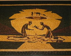 ll of the murals which adorn the walls in the auditorium (see pic it right). All the murals are made entirely of half ears of corn, which is specially planted and hand-picked after it is dried in the fields. There are 11 colors of corn available to the designers of the murals each year.
But what I really want to talk about in this blog is the land and the crops and my impressions of what I'm seeing. It seems, in my memory, that from the time we started in Indiana, until halfway across Minnesota, landforms were the same, flat, with some gentle rises you could not call hills. This land was covered with obviously rotating crops of corn and soybeans. Fields extending as far as the eye could see on each side of the highway. All the corn fields I have seen before this trip combined would not equal one of these fields. Sitting high in the RV, I get a different perspective than I would from a car, and that may contribute to my feeling of the endlessness of these fields. Anyway, I was awed.
While I was on the phone talking with my son Erik, we came upon the Missouri River as it swings north through eastern South Dakota. While talking, I was moving from place to place in the RV to get different views of that beautiful valley. The river was wide and beautiful, but the impression I got from driving into the Valley was overwhelming. We were going downhill fairly steeply and ahead of us across the river was a slope of land up to an escarpment. This slope was covered with dark and light grasses and evergreen trees of dark green color. I know no camera could record what I was seeing at that moment.
Somewhere in central North Dakota, the corn crop ceases to exist. Suddenly, or so it seemed, we were into grass country. Huge fields of hay crop were visible on each side. In some of the fields, the large round bales had been left where they fell and just scattered over the landscape. In others, the bales have been gathered into long rows, seemingly placed on the crest of ridges. I have no idea why a farmer would choose one or the other. It's curious how sometimes I want some information, and I have no idea where to get it.
I began to see a beautifully colored landscape. In the fields where the winter wheat had been cut, there remained a golden stubble. In the fields where the grass was still growing, there was a tawny sea with ripples working through the tall grasses. Once in awhile, there would be a deep green field where an unknown crop was growing very low to the ground. Lastly, there was rich, black earth of fields already turned from last year's winter wheat and ready for planting this year's. Further west, there were fewer fields of wheat and the landscape became hillier. Herds of beef cattle dotted the hillsides.I was surprised by how few herds were purebreds. There were black cattle with white faces, Angus with red or brown tones in their black bodies, and black cows being followed by white calves. The land was very dry, and in the valleys between hills, there were earthen dams to create waterholes.
I was fascinated by the Cheyenne River Valley. Along the winding, meandering river, on both banks were small trees, not more than 20 feet tall, which I assumed were cottonwoods. It seems in my memory, then every Western book or movie, has a scene in the cottonwoods along the river. Anyway, the Cheyenne River Valley brought to life my preconceptions of what that looks like. On the edges of the river valley was an escarpment, a sharp rise from the floor of the river valley to a plateau 30 or 40 feet higher. It was like flooding had washed away the land to a distance far wider than the current river. These old river banks were now covered with grasses and bushes that were many shades of tan, yellow and green. It was a really refreshing scene for the eyes.
In my last blog, I forgot to mention a sight that greeted me as we cross the Mississippi from Wisconsin and Minnesota. We were traveling on Interstate 90. The road surface was concrete. As with many concrete roads, the two lanes were separated by a crack. The novel thing was that this small crack was filled with grass! I expect grass in the middle of the back roads of Vermont, but not on Interstate 90!
We toured the Badlands of South Dakota yesterday (see pic it right). I'm really not sure what to say. First, it is a scene of destruction due to severe water erosion. Second, it reminded me on my trip through the Southwest, where the Grand Canyon and others are due to the same causes. It is a wasteland.beautiful in its own way. The depth of the canyons (?) was awe-inspiring and a mite frightening when you got near the edge. Mostly, I love the way the layers of sediment were revealed by the erosion. Each layer has a distinct color from gravies tan is to red brown's to rosy red's. Up close (see pic), I discovered it's composed of sandstone with a lot of play in it. As the sandstone erodes, that clay slides down the face of the hills and when you walk on it, fills the treads of your shoes. It is also slippery when wet. We traveled along the heights of part of the Badlands so we could look down into the canyons and then we traveled along the base of part of the Badlands so we could look up through the small valleys cut into the rock. In one section, I was sure I had seen a distinct yellow coloration in the rock. As I tried to photograph it while we were moving (a hopeless task), I realized that the yellow came from the grasses that were growing on the low slopes of the eroded hills. It blended in so perfectly. I thought it was rock.
Last night we went to Mount Rushmore to see the lighting of the famous carvings. None of the pictures of the lighting came out, but some different perspectives on mode is usually shown can be seen in the pics here. I enjoyed it, but my host loved it again.
ll of the murals which adorn the walls in the auditorium (see pic it right). All the murals are made entirely of half ears of corn, which is specially planted and hand-picked after it is dried in the fields. There are 11 colors of corn available to the designers of the murals each year.But what I really want to talk about in this blog is the land and the crops and my impressions of what I'm seeing. It seems, in my memory, that from the time we started in Indiana, until halfway across Minnesota, landforms were the same, flat, with some gentle rises you could not call hills. This land was covered with obviously rotating crops of corn and soybeans. Fields extending as far as the eye could see on each side of the highway. All the corn fields I have seen before this trip combined would not equal one of these fields. Sitting high in the RV, I get a different perspective than I would from a car, and that may contribute to my feeling of the endlessness of these fields. Anyway, I was awed.
While I was on the phone talking with my son Erik, we came upon the Missouri River as it swings north through eastern South Dakota. While talking, I was moving from place to place in the RV to get different views of that beautiful valley. The river was wide and beautiful, but the impression I got from driving into the Valley was overwhelming. We were going downhill fairly steeply and ahead of us across the river was a slope of land up to an escarpment. This slope was covered with dark and light grasses and evergreen trees of dark green color. I know no camera could record what I was seeing at that moment.
Somewhere in central North Dakota, the corn crop ceases to exist. Suddenly, or so it seemed, we were into grass country. Huge fields of hay crop were visible on each side. In some of the fields, the large round bales had been left where they fell and just scattered over the landscape. In others, the bales have been gathered into long rows, seemingly placed on the crest of ridges. I have no idea why a farmer would choose one or the other. It's curious how sometimes I want some information, and I have no idea where to get it.
I began to see a beautifully colored landscape. In the fields where the winter wheat had been cut, there remained a golden stubble. In the fields where the grass was still growing, there was a tawny sea with ripples working through the tall grasses. Once in awhile, there would be a deep green field where an unknown crop was growing very low to the ground. Lastly, there was rich, black earth of fields already turned from last year's winter wheat and ready for planting this year's. Further west, there were fewer fields of wheat and the landscape became hillier. Herds of beef cattle dotted the hillsides.I was surprised by how few herds were purebreds. There were black cattle with white faces, Angus with red or brown tones in their black bodies, and black cows being followed by white calves. The land was very dry, and in the valleys between hills, there were earthen dams to create waterholes.
I was fascinated by the Cheyenne River Valley. Along the winding, meandering river, on both banks were small trees, not more than 20 feet tall, which I assumed were cottonwoods. It seems in my memory, then every Western book or movie, has a scene in the cottonwoods along the river. Anyway, the Cheyenne River Valley brought to life my preconceptions of what that looks like. On the edges of the river valley was an escarpment, a sharp rise from the floor of the river valley to a plateau 30 or 40 feet higher. It was like flooding had washed away the land to a distance far wider than the current river. These old river banks were now covered with grasses and bushes that were many shades of tan, yellow and green. It was a really refreshing scene for the eyes.
In my last blog, I forgot to mention a sight that greeted me as we cross the Mississippi from Wisconsin and Minnesota. We were traveling on Interstate 90. The road surface was concrete. As with many concrete roads, the two lanes were separated by a crack. The novel thing was that this small crack was filled with grass! I expect grass in the middle of the back roads of Vermont, but not on Interstate 90!
We toured the Badlands of South Dakota yesterday (see pic it right). I'm really not sure what to say. First, it is a scene of destruction due to severe water erosion. Second, it reminded me on my trip through the Southwest, where the Grand Canyon and others are due to the same causes. It is a wasteland.beautiful in its own way. The depth of the canyons (?) was awe-inspiring and a mite frightening when you got near the edge. Mostly, I love the way the layers of sediment were revealed by the erosion. Each layer has a distinct color from gravies tan is to red brown's to rosy red's. Up close (see pic), I discovered it's composed of sandstone with a lot of play in it. As the sandstone erodes, that clay slides down the face of the hills and when you walk on it, fills the treads of your shoes. It is also slippery when wet. We traveled along the heights of part of the Badlands so we could look down into the canyons and then we traveled along the base of part of the Badlands so we could look up through the small valleys cut into the rock. In one section, I was sure I had seen a distinct yellow coloration in the rock. As I tried to photograph it while we were moving (a hopeless task), I realized that the yellow came from the grasses that were growing on the low slopes of the eroded hills. It blended in so perfectly. I thought it was rock.
Last night we went to Mount Rushmore to see the lighting of the famous carvings. None of the pictures of the lighting came out, but some different perspectives on mode is usually shown can be seen in the pics here. I enjoyed it, but my host loved it again.
Thursday, August 16, 2007
Tripping
We've been traveling since the fourth of August, when we left Hyde Park, New York for Delaware to visit Michele and Joe, Mike and Peggy's daughter and son-in-law. We left Delaware for a few hours in Pennsylvania with Kristi, their other daughter.
Then the traveling really started. We drove for about 12 hours from Central Pennsylvania to Central Indiana, Decatur. We moved from the car to the RV, spent the night and left the next morning, heading west and north. I found that Indiana was flat, and as corny as Kansas is reputed to be(according to the song). We turned north in central Illinois and camped in South Beloit, about 1 mile from the Wisconsin border. From what I saw of Illinois, it's as corny as Indiana.
I want to talk about impressions I've had in this first week of travel. I have marveled at the flatness of the land, the richness of the crops, the sheer greenness of the landscape. I was excited as we crossed the Mississippi River at its size this far north and at the lock visible from the bridge. A tug pushing six or eight barges was passing under the bridge as we crossed it. Just north of the bridge was a small dam (small in height) with a lock at one end. I guess I had been unaware of the fact that the Mississippi was navigable this far north (between Wisconsin and Minnesota). Anyway, a surprise and a beautiful sight.
Driving in Wisconsin, or was it Minnesota, I saw a billboard advertising the Spam Museum!! Mine hosts immediately suggested we detour to see this wonder. No, we didn't. (Peggy, who is listening to me dictate this, whispered, Minnesota). One of the beautiful sites I have seen while traveling is the wind farm or windmill farm, whichever is the correct way to refer to it. Driving the flat lands of the Midwest, it is wonderful to see on the horizon, Where there is a slight ridge, I would spot the blade of a propeller. Slowly, the blade grows to three and you can see the supporting post of the windmill. Moving your eyes along the ridge, you could see more and more of these windmills coming into view. The supporting posts are 40 to 50 feet high, and the blades are 25 to 30 feet long. Some of the wind farms have 25 to 50 windmills. I think they're a beautiful sight. As I watch them, a comparison between their beauty, their use of an endless source of power, their non-polluting functionality and nuclear power and all of its attendant problems, especially those of disposal, repeatedly occurred to me. I'm not sure how I would feel if I lived on Cape Cod. But right now I'm a windmill advocate.
Having told you about the endless cornfields I've seen have to tell you that there is an intervening crop, which seems just as endless, but grows so much lower that you have to think about it. This crop is soybeans. As far as I can determine, crops are rotated in alternate years between corn and soybeans. Most soybean fields have stray stalks of corn here and there scattered through them. If I remember my science,( or is it the farmer's sons training,) beans are legumes which you put nitrogen into the soil thus replacing the element which corn strips from the soil.
Yesterday, Wednesday the 15th, Mike and I went to the county fair here in Fairmont Minnesota. I had seen a leaflet describing the activities at the fair, day by day. Wednesday was senior citizen day, half-price (three dollars). Plus, there were a number of donkey, mule, and horse competitions. I have never seen a donkey or mule competition of any sort so I was all hot to go. The first activities were halter competitions for mules (no donkeys showed so that was canceled). In some of the activities the mules were compared to each other and the best was chosen. Others were judged on the showmanship of the human handler. Similar competitions were held for horses, including Percheron's, Clydesdales, and Belgians. Two little girls maybe aged 10 and 12, led hulking great Clydesdale geldings around the ring, including the length of the Ring at a trot. No reins, no bits, no help. Just halters. Amazing! The last part of the competition we watched was called a Khana. This consisted of an obstacle course designed to cause an ill trained animal to shy or bolt. There was a narrow wooden bridge with flowers in the handrails, a rapping plank where the rider had to dismount and walk down and lead the horse beside, a barrel to be stepped or jumped over, a gate to be opened and closed while mounted, and a water obstacle, which had to be walked through. Some of the mule riders were simply amazing. The training, the patience, the sheer beauty of the performance.
I must say I am enjoying life on the road. Today, acquaintances of Mike and Peggy invited us to brunch. We had wonderful homemade pancakes, and omelettes in a bag. You mix up the eggs and ham and cheese, etc. in sealable sandwich baggie, put it in a pot of boiling water for eight to 10 minutes and voilà, omelettes. The point is not the food but the open friendliness of the people I am meeting. Talk about Southern hospitality. The other thing I'm enjoying somewhat secretly is the distinctive accents I'm hearing. Olie Olafsen really did affect the speech of Minnesotans.
More pics.
Then the traveling really started. We drove for about 12 hours from Central Pennsylvania to Central Indiana, Decatur. We moved from the car to the RV, spent the night
and left the next morning, heading west and north. I found that Indiana was flat, and as corny as Kansas is reputed to be(according to the song). We turned north in central Illinois and camped in South Beloit, about 1 mile from the Wisconsin border. From what I saw of Illinois, it's as corny as Indiana.I want to talk about impressions I've had in this first week of travel. I have marveled at the flatness of the land, the richness of the crops, the sheer greenness of the landscape. I was excited as we crossed the Mississippi River at its size this far north and at the lock visible from the bridge. A tug pushing six or eight barges was passing under the bridge as we crossed it. Just north of the bridge was a small dam (small in height) with a lock at one end. I guess I had been unaware of the fact that the Mississippi was navigable this far north (between Wisconsin and Minnesota). Anyway, a surprise and a beautiful sight.
Driving in Wisconsin, or was it Minnesota, I saw a billboard advertising the Spam Museum!! Mine hosts immediately suggested we detour to see this wonder. No, we didn't. (Peggy, who is listening to me dictate this, whispered, Minnesota). One of the beautiful sites I have seen while traveling is the wind farm or windmill farm, whichever is the correct way to refer to it. Driving the flat lands of the Midwest, it is wonderful to see on the horizon, Where there is a slight ridge, I would spot the blade of a propeller. Slowly, the blade grows to three and you can see the supporting post of the windmill. Moving your eyes along the ridge, you could see more and more of these windmills coming into view. The supporting posts are 40 to 50 feet high, and the blades are 25 to 30 feet long. Some of the wind farms have 25 to 50 windmills. I think they're a beautiful sight. As I watch them, a comparison between their beauty, their use of an endless source of power, their non-polluting functionality and nuclear power and all of its attendant problems, especially those of disposal, repeatedly occurred to me. I'm not sure how I would feel if I lived on Cape Cod. But right now I'm a windmill advocate.
Having told you about the endless cornfields I've seen have to tell you that there is an intervening crop, which seems just as endless, but grows so much lower that you have to think about it. This crop is soybeans. As far as I can determine, crops are rotated in alternate years between corn and soybeans. Most soybean fields have stray stalks of corn here and there scattered through them. If I remember my science,( or is it the farmer's sons training,) beans are legumes which you put nitrogen into the soil thus replacing the element which corn strips from the soil.
Yesterday, Wednesday the 15th, Mike and I went to the county fair here in Fairmont Minnesota. I had seen a leaflet describing the activities at the fair, day by day. Wednesday was senior citizen day, half-price (three dollars). Plus, there were a number of donkey, mule, and horse competitions. I have never seen a donkey or mule competition of any sort so I was all hot to go. The first activities were halter competitions for mules (no donkeys showed so that was canceled). In some of the activities the mules were compared to each other and the best was chosen. Others were judged on the showmanship of the human handler. Similar competitions were held for horses, including Percheron's, Clydesdales, and Belgians. Two little girls maybe aged 10 and 12, led hulking great Clydesdale geldings around the ring, including the length of the Ring at a trot. No reins, no bits, no help. Just halters. Amazing! The last part of the competition we watched was called a Khana. This consisted of an obstacle course designed to cause an ill trained animal to shy or bolt. There was a narrow wooden bridge with flowers in the handrails, a rapping plank where the rider had to dismount and walk down and lead the horse beside, a barrel to be stepped or jumped over, a gate to be opened and closed while mounted, and a water obstacle, which had to be walked through. Some of the mule riders were simply amazing. The training, the patience, the sheer beauty of the performance.
I must say I am enjoying life on the road. Today, acquaintances of Mike and Peggy invited us to brunch. We had wonderful homemade pancakes, and omelettes in a bag. You mix up the eggs and ham and cheese, etc. in sealable sandwich baggie, put it in a pot of boiling water for eight to 10 minutes and voilà, omelettes. The point is not the food but the open friendliness of the people I am meeting. Talk about Southern hospitality. The other thing I'm enjoying somewhat secretly is the distinctive accents I'm hearing. Olie Olafsen really did affect the speech of Minnesotans.
More pics.
Wednesday, August 15, 2007
Madison
On our way west. We've traveled through several states new to me. We picked up the camper in Indiana, drove halfway across Illinois, and then turn north into Wisconsin, my third new state on the trip.
As an old history teacher, I had often read about it and toss about Robert Lafollette, and he is progressive party in Wisconsin. Many authors wrote about the wonderful Nexis, between the state government, and the State University in Madison, Wisconsin. I envisioned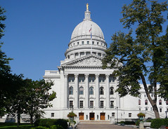 a mall like that in Washington, DC with the capital at one end and the University of the other where the learned professors of the University would advise and lead the legislators in the state capital. So when it became clear that we would be passing very near to Madison, I sponsored a quick side trip to see for myself.
The Capitol building and in Madison, is the third to stand on that site. The first was replaced by one "more beautiful." The second burned in 1904. This is the third, which was completed in 1911. It is massive (see pic at right).
Inside, there is a greater variety of colored m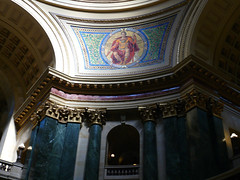 arble than I have seen anywhere else. This pic doesn't do justice to the beauty of the green columns, and red floor tiles, and red band around the central room under the dome. Anyway, one for its era, when you really couldn't overdo anything, it is a beauty.
Outside, the Avenue stretching toward the University is like any other city street and the University is not placed as a balance to the Capitol building, but is like any other university. I was disappointed.
More pics here.
As an old history teacher, I had often read about it and toss about Robert Lafollette, and he is progressive party in Wisconsin. Many authors wrote about the wonderful Nexis, between the state government, and the State University in Madison, Wisconsin. I envisioned
a mall like that in Washington, DC with the capital at one end and the University of the other where the learned professors of the University would advise and lead the legislators in the state capital. So when it became clear that we would be passing very near to Madison, I sponsored a quick side trip to see for myself.The Capitol building and in Madison, is the third to stand on that site. The first was replaced by one "more beautiful." The second burned in 1904. This is the third, which was completed in 1911. It is massive (see pic at right).
Inside, there is a greater variety of colored m
arble than I have seen anywhere else. This pic doesn't do justice to the beauty of the green columns, and red floor tiles, and red band around the central room under the dome. Anyway, one for its era, when you really couldn't overdo anything, it is a beauty.Outside, the Avenue stretching toward the University is like any other city street and the University is not placed as a balance to the Capitol building, but is like any other university. I was disappointed.
More pics here.
Tuesday, August 14, 2007
Philadelphia
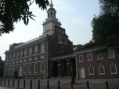
Did you know, there is a large clock on the end of the Independence Hall in Philadelphia? I wish you're surprised to see it (see the picture to the right).
I'm traveling with my sister Peg and her husband, Mike Butler. We visited their daughter, Michelle and her husband Joe in Delaware for a few days. Joe, a native of Philadelphia, offered a guided tour of his hometown. We spent an exciting, exhausting, heat filled day seeing the historic sites and eating at Joe's favorite restaurant.
We started by getting tickets to Independence Hall, and Dolly Madison's home at the visitor center. We got the first tour are of Independence Hall where the electricity had failed and the air-conditioning was off. I particularly enjoyed the room where the Constitution was written. I had seen innumerable pictures of the room and of the painting, which was later completed, but it was still a thrill to see the real room. Somehow, I had never known that the delegates were seated in the room geographically starting with New Hampshire. In one corner and ending with Georgia in the other.
The visit to the Dolly Madison home went mostly as expected.One interesting fact came to light.we noticed that the kitchen was a very small. The guide, responding to our questions, told us that most of the city households did not do their own cooking. Rather, there were bakeries where they would buy their bread, bring pots of beans to be baked, and other such edibles. This was a real surprise to me. I guess I never heard about the city life, as opposed to rural life.
We also visited the Bishop White house which was built by an upper class man, who was the first Episcopal Bishop of Philadelphia. The house was lavish, compared to Dolly Madison's and the contrast was instructive.
We took a walking tour of the historic downtown section of Philadelphia, seeing Carpenters Hall (a very early union hall), the first and second national Banks, had lunch at city Tavern (built in 1774), and ended at the Constitution Center. They are, we saw a film on the Constitution saw historic documents, and what fascinated me the most out of room on all the prawns s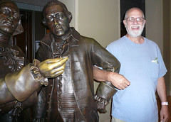 culptures of each of the delegates to the Constitutional convention. Each was labeled by name and colony. I had to have a pic with a delegate from New Hampshire.
While in Delaware, I visited the Hagley Museum. It is the home of the first DuPont to come over from France, and he was trained in France to make gunpowder and in 1804, he was urged by then President Jefferson to apply this knowledge and make gunpowder for the fledgling United States. He bought land along the Brandywine River in Delaware and established a gunpowder mill. I was fascinated by the way waterpower. Once you lose to to combine the three parts of gunpowder. It is not a chemical process, but a physical one way or the three components are mixed union that specific portions. And then sort of ground together into a fine fine powder. Each part of which must have all three elements in direct proportion to waterpower issue is to turn large cast iron wheels inside a bowl shaped container into which the rough mixture is dumped. The slightest spark will set off an explosion, which makes this a very dangerous occupation. We were told that the house, which set high on a hill above the river. Directly behind the mail had suffered 28 explosions or so. A special set of wooden railroad rails were made to carry the gunpowder after it was mixed. From these mails to the area where it was packaged. The wife and daughters of the original DuPont made the sax into which the gunpowder was placed. Some two or three generations later, the DuPont's got into chemical manufacturing.
The rest of the pics are here.
I'm traveling with my sister Peg and her husband, Mike Butler. We visited their daughter, Michelle and her husband Joe in Delaware for a few days. Joe, a native of Philadelphia, offered a guided tour of his hometown. We spent an exciting, exhausting, heat filled day seeing the historic sites and eating at Joe's favorite restaurant.
We started by getting tickets to Independence Hall, and Dolly Madison's home at the visitor center. We got the first tour are of Independence Hall where the electricity had failed and the air-conditioning was off. I particularly enjoyed the room where the Constitution was written. I had seen innumerable pictures of the room and of the painting, which was later completed, but it was still a thrill to see the real room. Somehow, I had never known that the delegates were seated in the room geographically starting with New Hampshire. In one corner and ending with Georgia in the other.
The visit to the Dolly Madison home went mostly as expected.One interesting fact came to light.we noticed that the kitchen was a very small. The guide, responding to our questions, told us that most of the city households did not do their own cooking. Rather, there were bakeries where they would buy their bread, bring pots of beans to be baked, and other such edibles. This was a real surprise to me. I guess I never heard about the city life, as opposed to rural life.
We also visited the Bishop White house which was built by an upper class man, who was the first Episcopal Bishop of Philadelphia. The house was lavish, compared to Dolly Madison's and the contrast was instructive.
We took a walking tour of the historic downtown section of Philadelphia, seeing Carpenters Hall (a very early union hall), the first and second national Banks, had lunch at city Tavern (built in 1774), and ended at the Constitution Center. They are, we saw a film on the Constitution saw historic documents, and what fascinated me the most out of room on all the prawns s
culptures of each of the delegates to the Constitutional convention. Each was labeled by name and colony. I had to have a pic with a delegate from New Hampshire.While in Delaware, I visited the Hagley Museum. It is the home of the first DuPont to come over from France, and he was trained in France to make gunpowder and in 1804, he was urged by then President Jefferson to apply this knowledge and make gunpowder for the fledgling United States. He bought land along the Brandywine River in Delaware and established a gunpowder mill. I was fascinated by the way waterpower. Once you lose to to combine the three parts of gunpowder. It is not a chemical process, but a physical one way or the three components are mixed union that specific portions. And then sort of ground together into a fine fine powder. Each part of which must have all three elements in direct proportion to waterpower issue is to turn large cast iron wheels inside a bowl shaped container into which the rough mixture is dumped. The slightest spark will set off an explosion, which makes this a very dangerous occupation. We were told that the house, which set high on a hill above the river. Directly behind the mail had suffered 28 explosions or so. A special set of wooden railroad rails were made to carry the gunpowder after it was mixed. From these mails to the area where it was packaged. The wife and daughters of the original DuPont made the sax into which the gunpowder was placed. Some two or three generations later, the DuPont's got into chemical manufacturing.
The rest of the pics are here.
Subscribe to:
Comments (Atom)