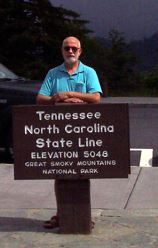
A critic advised me that I had skipped a number of interesting things in my San Francisco last day blog. Unfortunately, she's right. I got lazy and decided not to rig up the microphone and just type a few thoughts. Now I know why I bought this dictating program. I'm too lazy to type! By the way, yesterday's blog said Marin Heights with the correct name is Marin Highlands. Also, I failed to mention that San Quentin prison is within miles of this place where we're camping. We went by at on the ferry.
So , about yesterday. We sort of wandered through the city to see those places on my list which were not crossed off yet. We started with another cable car ride to the famous crooked street, Lombard Street. I was a little disappointed but glad I saw it. Then we found, with the help of a native, the Italian section. We came upon a pretty little park with a band playing, a crowd watching, mounted policemen patrolling, and to classic MG's -- the old square cut type with right-hand drive. Beautiful! Just up the street, we found the U.S. restaurant which had been recommended. We had a (is divine an adjective for food?) meal. Stuffed is what we were. The waitress, who was clearly the boss, the hostess, the organizer, offered pasta with the dinners. Peggy said she'd take anything. When the waitress offered the same thing to Mike, he asked like what? We were all shocked to hear not just penne and spaghetti, but ravioli. They both ordered ravioli which turned out to be the restaurant's specialty. Hand stuffed with meat and spinach and cheese! Damn, I should've ordered that! But I had my fettuccine Alfredo with chicken. It was just as good!
Then we managed to find a cable car to take us to Chinatown again. Some one of the books I had researched said be sure to go to this alley where the Chinese fortune cookie factory was. We found it with the help of the city delivery postal worker! It was great to see how fortune cookies are made. The thin wafers are on a conveyor system held vertically as they come out of the oven. The worker talks one hot way for off the conveyor, picks up a fortune slip, holds it against the way for which she drapes over a horizontal metal pin. The wafer is still pliable and droops down over the pin and gets a quick pinch from the operator. And on to the next one. I, of course, couldn't resist the almond cookies also made at that bakery. They are delicious. It went on from there to the oldest cathedral in San Francisco, St. Mary's, which is located on the corner of Chinatown.
We then took my favorite form of transportation down to the Embarcadero. I simply can't tell you how much I enjoy riding on the left running board of the cable car. I don't know if it's because I get a thrill out of being able to ride such a thing up and down those steep hills, without a panic pill. After all, it's the closest I'll ever get to a roller coaster! I just love meeting a cable car going the opposite direction. You pass within inches of the people coming at you. I was wearing a backpack and if I hadn't turned it will people on the left side of the oncoming cable car. Maybe I'm turning into a thrill seeker in my old age. Do you think that's possible?
Today we drove south from Marin County, across the Golden gate Bridge, south across San Francisco and onto Route 1. This is the Coast Highway. We followed it for about 30 miles south. One of the first things that caught my attention when large signs saying Pumpkins,U Pick Strawberries, Corn Maze. Imagine those three crops available to the public on the same day. We saw lots of truck farm fields including one filled with cabbage like plants, Brussels sprouts?
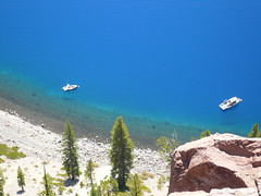
We stopped at Pompanio State Beach. Gorgeous breakers, beautiful sand, me in the water. I just had to get a toe into the Pacific! I succeeded and then Peggy said I needed proof, a picture. I went back in, turned toward Peggy, and was swamped above my knees by breaking wave. Much warmer than Maine in August. In fact, look at the pics. Those after my dunking are from this trip. Another unforgettable day. I am so lucky.
Tuesday, September 25, 2007
Sunday, September 23, 2007
San Francisco
Thanks to my friend Dottie, I now know that the flower I saw on the coast road near Klamath was foxglove.
We left the Eureka area and traveled south on Route 101 over the same 60 miles we had toured in the car the previous day. It is amazing how different the perspective is when you're sitting high in an RV looking out of a picture window sized windshield.At one point, we passed a sign I hadn't even seen the previous day. It was higher than my head in the RV and showed the high water mark in the 1964 flood. At that point the river was 30 or 40 feet below us. That Eel River flows north alongside 101 through the Redwood Forest. It winds through a channel it has cut and the road winds with it and across it a hundred times. I wish I had counted the bridges over the Eel. These bridges were extraordinarily high. In the Park we read about the floods and discovered that the bridges had been washed out in the flood and so were rebuilt higher. The funny thing is they were rebuilt only 2 feet higher! In 1964 they received 101 inches of rain. The average rainfall is 51 inches. That might explain the flooding.
We were driving through Mendocino County, still on 101, when suddenly we were in the middle of the largest grape fields I've ever seen. On this trip I've seen endless fields of corn, of wheat, of hay, and now of grapes. Mike spotted trailer truck loads of bright red grapes. We continued with the vineyards into Sonoma County. I discovered this is called the Russian River Valley. The vineyards went up the hills on the sides of the Valley to a certain elevation and stopped abruptly. If the hill was low, the vineyards went right over the top. A little further down the valley I saw a sign, "U Pick, Sweet Juicy Strawberries". This was on September 19, 2007.
We camped just off 101 in Marin County, just north of the Golden Gate Bridge. The f irst day I ventured into the city by bus to go to the VA. Not knowing the system, I crossed the city by bus four times that afternoon! It took one hour each way but I followed each trip carefully on the map and learned how the city is set up. As I left the city to return to the RV park, I was crossing the Golden gate Bridge at 7 p.m.. Looking back toward San Francisco, I realized it's a white city. Almost all the buildings are white or very light. Here and there, lights were beginning to come on and sparkle in the twilight. Northeast, across the bay, the sunlight was reflecting off windows in the Oakland/Berkeley area. A huge sailboat was proceeding away from me into the bay. Alcatraz sat square in the middle with a ferry boat passing on each side and another across the front. I Fell In Love!!
The next day, we took a tour of the city. The guide was entertaining and informative. He took us all around but I especially enjoyed the view from Twin Peaks and from the Marin side of the Golden Gate Bridge. He dropped us off on Market Street where we took a bus to Haight-Ashbury. Then we rode the cable car! It was like an amusement park ride! I rode on the running board in the front position while we climbed a hill and then went down the other side. I liked it so much, I insisted we get right back on going the other way! We ate in Chinatown and then rode another cable car. To cap the evening, we rode one of the old-fashioned electric streetcars around the Embarcadero. What a city! Tomorrow, I have to try the ferry service across the Bay.
Today we drove to Marin Highlands. These are high bluffs just West of the Golden Gate Bridge. The views across the Bay and into San Francisco were unmatchable. I'm sure the pics don't touch it, but look anyway.
Went in by ferry today. It was too fast a trip! Saw the bridges, Alcatraz, and the piers. Rode the cable car again (twice more), saw more of the city and said good bye on the Bridge! Sad to leave but onward!!
We left the Eureka area and traveled south on Route 101 over the same 60 miles we had toured in the car the previous day. It is amazing how different the perspective is when you're sitting high in an RV looking out of a picture window sized windshield.At one point, we passed a sign I hadn't even seen the previous day. It was higher than my head in the RV and showed the high water mark in the 1964 flood. At that point the river was 30 or 40 feet below us. That Eel River flows north alongside 101 through the Redwood Forest. It winds through a channel it has cut and the road winds with it and across it a hundred times. I wish I had counted the bridges over the Eel. These bridges were extraordinarily high. In the Park we read about the floods and discovered that the bridges had been washed out in the flood and so were rebuilt higher. The funny thing is they were rebuilt only 2 feet higher! In 1964 they received 101 inches of rain. The average rainfall is 51 inches. That might explain the flooding.
We were driving through Mendocino County, still on 101, when suddenly we were in the middle of the largest grape fields I've ever seen. On this trip I've seen endless fields of corn, of wheat, of hay, and now of grapes. Mike spotted trailer truck loads of bright red grapes. We continued with the vineyards into Sonoma County. I discovered this is called the Russian River Valley. The vineyards went up the hills on the sides of the Valley to a certain elevation and stopped abruptly. If the hill was low, the vineyards went right over the top. A little further down the valley I saw a sign, "U Pick, Sweet Juicy Strawberries". This was on September 19, 2007.
We camped just off 101 in Marin County, just north of the Golden Gate Bridge. The f
irst day I ventured into the city by bus to go to the VA. Not knowing the system, I crossed the city by bus four times that afternoon! It took one hour each way but I followed each trip carefully on the map and learned how the city is set up. As I left the city to return to the RV park, I was crossing the Golden gate Bridge at 7 p.m.. Looking back toward San Francisco, I realized it's a white city. Almost all the buildings are white or very light. Here and there, lights were beginning to come on and sparkle in the twilight. Northeast, across the bay, the sunlight was reflecting off windows in the Oakland/Berkeley area. A huge sailboat was proceeding away from me into the bay. Alcatraz sat square in the middle with a ferry boat passing on each side and another across the front. I Fell In Love!!The next day, we took a tour of the city. The guide was entertaining and informative. He took us all around but I especially enjoyed the view from Twin Peaks and from the Marin side of the Golden Gate Bridge. He dropped us off on Market Street where we took a bus to Haight-Ashbury. Then we rode the cable car! It was like an amusement park ride! I rode on the running board in the front position while we climbed a hill and then went down the other side. I liked it so much, I insisted we get right back on going the other way! We ate in Chinatown and then rode another cable car. To cap the evening, we rode one of the old-fashioned electric streetcars around the Embarcadero. What a city! Tomorrow, I have to try the ferry service across the Bay.
Today we drove to Marin Highlands. These are high bluffs just West of the Golden Gate Bridge. The views across the Bay and into San Francisco were unmatchable. I'm sure the pics don't touch it, but look anyway.
Went in by ferry today. It was too fast a trip! Saw the bridges, Alcatraz, and the piers. Rode the cable car again (twice more), saw more of the city and said good bye on the Bridge! Sad to leave but onward!!
Wednesday, September 19, 2007
Coast and Redwoods
California Coast
We left Redding in the morning when it was about 60°. This was the high point on the thermometer for the day. We went west on Route 299 toward Arcata and Eureka on the northern California coast. It was only about 120 miles but it was the worst road we’ve traveled in the RV. We climbed out of Redding and into the Trinity Alps. This north-south mountain chain is probably part of the Cascade Mountains. We started at about 500 feet altitude climbing to 3000 feet, dropped back down to 1800 feet, climbed to 3500 feet, dropped back down to 1800 feet. Then we climbed the coastal mountain range before coming down to sea level at Arcata. Twice we came to warning signs saying 7% downgrade next 7 miles. Not the type of road Mike likes to take the RV on.
In addition to climbing at least three ridges, we followed the Trinity River through the Trinity Alps. This river flows west toward the Coast Range and has cut its way through sandstone mountains. The route twists and turns along the bank of the river through a narrow gulch. It’s really just wide enough for the river but a road has been cut into one side and then the other side, right out of the side of the mountains. The river is full of rock like the White River but the narrow valley reminds me of the Black River between Downers Corners and Proctorsville in Vermont. Sometimes, we climbed high above the river but still followed the twists and turns the valley. It was beautiful but sometimes a little scary with its precipitous drops.
As soon as we arrived in Arcata, Mike and Peggy took me to Trinidad. A little town set in a pretty little cove. I saw something unique there. It was a trolley car connected to a winch that used gravity to back down a railed incline into the ocean. A boat would move over the trolley car, the driver would grab onto a pole sticking up out of the water from the trolley car, and the winch would pull the car up the incline. As the car came out of the water, the boat would settle on it. At the top of the incline, an overhead electric hoist would lift the boat off the trolley moving it sidewards and settle it on its trailer which had been parked there. Truly a unique way to get a fishing boat out of water.
As soon as we arrived in this coastal area, I started seeing these tall cattail-like waving fronds. I finally asked a lady in Trinidad who identified this as Pampas grass. I don’t know what it looks like in other seasons about they are very attractive in the wild in this season.

Yesterday another first. Redwoods! We went north along Route 101 toward Crescent City. We traveled through a couple of state Redwood forests and the national Redwood Forest. Photographs simply do not capture what I saw. I knew they were large. I knew they were tall. But somehow that knowledge meant nothing. Poor Mike. He had to stop the car every 20 feet because I wanted to take another photo. I took over a hundred of them but I am really not satisfied with them. Size. I took this pic of Peggy and Mike inside a tree but…
Height. No pic does it. Check of the pics out here.
A couple of detours off on a one brought us wonderful views of the Pacific, which drove with boulders which signs explained are being scraped off the bottom of the ocean as the Pacific plate slides under the North American plate. Makes for a beautiful coastline. While on a detour, we came upon the mouth of the Klamath River. We had seen the Klamath Lake and Klamath Falls in Oregon and now we saw the end of the river. It may have been low tide, but what we saw was a sandbar with the river following an “S” curve through it. One side of the sandbar was the river and the other side was the breaking surf. I just loved all the people on the sandbar.
We spent another day in the redwoods are wrote called Avenue of the Giants. Awesome! I cannot get enough of these trees. Of the feeling evoked when walking in a grove is like that in a cathedral. It's awe inspiring. I love to just stand in the Grove and slowly turn a 360° circle. Giants every where you look. Sometimes they're even more awe inspiring when they are laying down. A diameter is unbelievable and the length, beyond imagination.

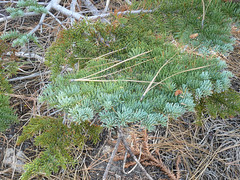
At the visitor center I found out there are three types of redwoods. The smallest is called the Dawn Redwood.it has fine needles which make me think of baby ferns. The one I've seen most of its call the Coast Redwood. It grows from about the California border down a hundred to a hundred and 50 miles along the coast. The third kind is the Giant Sequoia. We plan to go to the Sequoia national Park just south of Yosemite soon. These pics try to show the differences in the leaves. To the right is Dawn, below is Coast and to it's right is Sequoia.


On the way back, we stopped at a couple of the coastal towns to take some pictures of Victorian homes. These towns along the north coast of California must have had their heyday in the Victorian era since they have so much of that architecture. There is a famous mansion in Eureka which has it all. I'm sure you'll agree.
The last thing I want to talk about today is the barn architecture near Arcata California.There is something unique about this design, at least to my knowledge. barn has a raid in central portion where a hay loft door opens just under the eaves for the old hayforks which were used to lift loose hay in the days before bales. and the two sides come up to the side walls of that raised section. Nowhere have I seen this except in Arcata. Could we call these craftsmen barns like we have craftsman houses?

We left Redding in the morning when it was about 60°. This was the high point on the thermometer for the day. We went west on Route 299 toward Arcata and Eureka on the northern California coast. It was only about 120 miles but it was the worst road we’ve traveled in the RV. We climbed out of Redding and into the Trinity Alps. This north-south mountain chain is probably part of the Cascade Mountains. We started at about 500 feet altitude climbing to 3000 feet, dropped back down to 1800 feet, climbed to 3500 feet, dropped back down to 1800 feet. Then we climbed the coastal mountain range before coming down to sea level at Arcata. Twice we came to warning signs saying 7% downgrade next 7 miles. Not the type of road Mike likes to take the RV on.
In addition to climbing at least three ridges, we followed the Trinity River through the Trinity Alps. This river flows west toward the Coast Range and has cut its way through sandstone mountains. The route twists and turns along the bank of the river through a narrow gulch. It’s really just wide enough for the river but a road has been cut into one side and then the other side, right out of the side of the mountains. The river is full of rock like the White River but the narrow valley reminds me of the Black River between Downers Corners and Proctorsville in Vermont. Sometimes, we climbed high above the river but still followed the twists and turns the valley. It was beautiful but sometimes a little scary with its precipitous drops.
As soon as we arrived in Arcata, Mike and Peggy took me to Trinidad. A little town set in a pretty little cove. I saw something unique there. It was a trolley car connected to a winch that used gravity to back down a railed incline into the ocean. A boat would move over the trolley car, the driver would grab onto a pole sticking up out of the water from the trolley car, and the winch would pull the car up the incline. As the car came out of the water, the boat would settle on it. At the top of the incline, an overhead electric hoist would lift the boat off the trolley moving it sidewards and settle it on its trailer which had been parked there. Truly a unique way to get a fishing boat out of water.
As soon as we arrived in this coastal area, I started seeing these tall cattail-like waving fronds. I finally asked a lady in Trinidad who identified this as Pampas grass. I don’t know what it looks like in other seasons about they are very attractive in the wild in this season.
Yesterday another first. Redwoods! We went north along Route 101 toward Crescent City. We traveled through a couple of state Redwood forests and the national Redwood Forest. Photographs simply do not capture what I saw. I knew they were large. I knew they were tall. But somehow that knowledge meant nothing. Poor Mike. He had to stop the car every 20 feet because I wanted to take another photo. I took over a hundred of them but I am really not satisfied with them. Size. I took this pic of Peggy and Mike inside a tree but…
Height. No pic does it. Check of the pics out here.
A couple of detours off on a one brought us wonderful views of the Pacific, which drove with boulders which signs explained are being scraped off the bottom of the ocean as the Pacific plate slides under the North American plate. Makes for a beautiful coastline. While on a detour, we came upon the mouth of the Klamath River. We had seen the Klamath Lake and Klamath Falls in Oregon and now we saw the end of the river. It may have been low tide, but what we saw was a sandbar with the river following an “S” curve through it. One side of the sandbar was the river and the other side was the breaking surf. I just loved all the people on the sandbar.
We spent another day in the redwoods are wrote called Avenue of the Giants. Awesome! I cannot get enough of these trees. Of the feeling evoked when walking in a grove is like that in a cathedral. It's awe inspiring. I love to just stand in the Grove and slowly turn a 360° circle. Giants every where you look. Sometimes they're even more awe inspiring when they are laying down. A diameter is unbelievable and the length, beyond imagination.
At the visitor center I found out there are three types of redwoods. The smallest is called the Dawn Redwood.it has fine needles which make me think of baby ferns. The one I've seen most of its call the Coast Redwood. It grows from about the California border down a hundred to a hundred and 50 miles along the coast. The third kind is the Giant Sequoia. We plan to go to the Sequoia national Park just south of Yosemite soon. These pics try to show the differences in the leaves. To the right is Dawn, below is Coast and to it's right is Sequoia.
On the way back, we stopped at a couple of the coastal towns to take some pictures of Victorian homes. These towns along the north coast of California must have had their heyday in the Victorian era since they have so much of that architecture. There is a famous mansion in Eureka which has it all. I'm sure you'll agree.
The last thing I want to talk about today is the barn architecture near Arcata California.There is something unique about this design, at least to my knowledge. barn has a raid in central portion where a hay loft door opens just under the eaves for the old hayforks which were used to lift loose hay in the days before bales. and the two sides come up to the side walls of that raised section. Nowhere have I seen this except in Arcata. Could we call these craftsmen barns like we have craftsman houses?
Monday, September 10, 2007
California HERE I AM!

We spent a couple of days at Diamond Lake while we visited Crater Lake. I got up the last morning feeling happy as a lark. Mike and Peggy each noticed it. I, of course, could feel it. I've been debating whether the "high" was due to my experience the previous day at Crater Lake or was it due to the fact that I knew I'd be in California in a few hours? Honestly, California has been a dream of mine for such a long time, I really doubted I would ever get here. Anyway, I was on top of the world.
We proceeded down Route 97, through Klamath Falls and on to the border, leaving Oregon behind. I saw, on the Klamath River, a couple of big squares of logs floating down the river. Somehow, I think these are called booms. They are a large rectangle of logs hooked together with what look like chains, and the rectangle is filled with loose logs. The only thing missing from the scene was lumberjacks skipping from log to log.
We entered California still a 97, which is approximately in the middle of the state, East-West. Within a couple of miles, we passed over a good-sized hill and there was a wide valley filled with various irrigated crops. Each crop was part of a patchwork of colors and textures. Included in these crops were strawberries, flowering, not ready for picking but with some workers in the fields. Somehow, this perfectly fit my mental image of California. It surprised me. I always thought that I'd identify California with San Francisco or the beaches or something else, but crops, green and getting ready for harvest in the winter, struck me as perfect. I even saw crop- dusting (by a truck) far away across the valley. Strange, the mental images we carry.
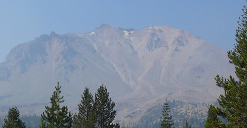
As we were heading toward I- 5, I spotted off in the far distance, the shadow of an outline of a cone shaped mountain. The haze was obscuring a real look. In fact, the sky has remained hazy when looking off in the distance. At home, I think of the three H's, hazy, hot and humid. The last word does not apply here. Hazy, yes. Hot, yes. So hot it set a record for this area and for me.It was 103 at the airport here in Redding California yesterday!!! But back to the mountain. As we continued south, more and more of the haze cleared until, finally, we came around a corner and there, in all its glory, was Mt. Shasta. Huge, snow-covered for at least its upper third, with granite cliffs and ridges showing through the snow. Magnificent.
In my mind, I compared Mt. Shasta to Mt. Washington in New Hampshire.I guess it was the way they both stand out from their surroundings. Anyway Mount Shasta is about 8000 feet higher than Mount Washington, some 14,000 feet versus 6200. So much for comparisons.
Here in Redding, there is a fantastic architectural/engineering marvel. Peggy and Mike had been there and wanted to show me their find. My first glimpse made me think of the new bridge type I've seen in Boston and Savanna. The kind where there is a vertical support and cables running out from each side like harp strings.I was surprised when we got close enough to see the vertical support was leaning in about a 30° angle away from me and the cables stretched only on one side of the vertical. This is a walking bridge and the floo
 r of the bridge is made of glass rectangles. Note the footprints (shoe shadows) in this pic. The bridge is simply a marvel. The off vertical piece balances against the suspended floor of the bridge on a 12 inch bearing. I kept my photographer busy. See the rest of the pics here. By the way, I walked onto the bridge before I realized I was walking on glass. I quickly moved to one of the two granite stripes but Mike was insistent that I walk on glass. He also insisted I touch the first cable I came to. It was vibrating! Needless to say, I touched no others. If you're ever in Redding, you've got to see this.
From the man-made to natures way, we next visited Lassen Volcanic National Park. It is promoted as a combination of Yellowstone and Yosemite. I was very disappointed that we saw no Rangers except the one selling tickets at the gate. I had a lot of questions especially about trees that I was unable to get answered. The visitors center was closed and locked. So I'll tell you about the Park and leave you with questions I can't answer.
Prior to Mount St. Helens, Lassen was the last volcano to erupt in California, in 1915
 . In the picture to the right, the mountain erupted just below the center peak. Eruption blew away rock which had formed in an earlier eruption 27,000 years ago. It was a reddish hue. Multi ton rocks were carried by snow avalanches as much as 5 miles from the eruption. No one was killed but all homes in the valley were wiped out. We saw a great deal of evidence of the older rock but very little of the new rock which formed in this eruption. In the picture, the caprock on the left of the picture is of the same color as the old reddish rock.
Further into the Park we found a caldera with a small dome shaped peak in the middle. The caldera was similar to Crater Lake's but incomplete in that it was not a complete circle. Having seen Crater Lake, it was easy to piece together the parts of the caldera still showing here. It is what is left of a mountain called Brokeoff Volcano, which was the same size as Lassen before it erupted. Also in the Park we saw some fumeroles (steam vents), some boiling water pots and some sulfur spots. Not as impressive as Yellowstone but of the same type and origin. No geysers, however.
Now, trees. Lassen is an evergreen forest. The park rises from around 1000 feet altitude to over 10,000 feet at the top of Lassen Peak. We exceeded 8000. A little funny. As we were climbing up toward the high point of the road in the park, Mike and Peggy kept hearing something. As we reached about 8000 feet, there was a loud bang. Peggy was sitting in the backseat and said WOW! Mike and I both jumped. Peggy found that our unopened Lays potato chip bag had burst open alo
 ng the top seam. It seems that Lays guarantees freshness only below 8000 feet.
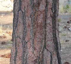
Trees, that's where I was. The pic at right is of a large pine near the entrance of the park. I was particularly impressed by the pattern in the bark. The black lines are recessed and the bark has a strong three-dimensional character. In the leaflet we got at the gate, the Park service says there are Jeffrey Pines near this point. Before I read that, I was convinced these were Ponderosa Pines, based on the bark and the large pine cones lying at their base. HELP!
There were also a number of other trees which intrigued me, They were growing at various altitudes. One was a ladder-like tree. The branches seem to grow in perfect steps and exactly balanced left and right. HELP!
Then there were the trees that looked like their bark had been shredded. The bark of the tree looked stringy. I thought of Cedar but my experience with Cedar is limited to 10 or 15 foot tall trees. Of these were double or triple that.
Then I started examining the needles on these evergreens whenever we stopped. Some sort of reminded me of hemlock. The branches were flat and the twigs at the end of th
 e branches spread out with short needles on each side of the twig. Another shown in this pic, made me think of Blue Spruce except only the end (new) needles were bluish and the needles were soft rather than spiky. HELP!
There, that should be enough questions. The rest of the pics are here.
Friday, September 7, 2007
Crater Lake
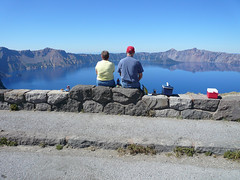
Today we went to crater Lake and I am still overwhelmed by its beauty. There just don’t seem to be words to describe what I saw or my feelings. We saw a film where the color of the lake was described as Safire. I honestly don’t know if that is the right word. When we first came upon the Lake, Peggy said look at the color along the edge and how it changes as it goes deeper. It’s Peacock. She was absolutely correct. I hope you can see in the picture to the right, what she saw.
Let me tell you a little of what either about Crater Lake today. The Lake fills an area about 6 miles in diameter. It is surrounded by caldera. I assumed that the caldera here in the caldera at Yellowstone were essentially from the same causes. I was totally wrong. In fact, it’s about as opposite as you can get. In Yellowstone, the explosion blew out the center of the circle and deposited debris, magma, dust along the edge of the circle making the caldera. Here at crater Lake, the magma rose around the 12,000 foot mountain venting in a series of volcanic eruptions. The venting of the magma left a void under the mountain which collapsed into the void. The top 5000 feet of the mountain crashed downward leaving a 4000 foot deep hole. Gradually, the whole filled about halfway with water, from rain and snowfall. There is no watercourse through the caldera dumping into or out of the Lake. There is one path leading down 1000 feet on the face of the cliff to the water level. We did not take that path! In Yellowstone, the magma vent remains under the surface and produces the geysers. Here, the implosion seems to have blocked most of the volcanic activity except for one volcano cone which rose shortly after the implosion and remains as an island.
Over and over again, I would say awesome! Or beautiful! View after view was so overwhelming that I began to think of the whole scene as something from a Technicolor movie or a painted backdrop for a play. I once saw a painting called Niagara Falls which made the artist rich. Frederich Church is the artist who painted in the famous Hudson Valley School and who built a beautiful home called Olana near Hyde Park, New York. I believe if any artist at that time had been able to paint Crater Lake and capture it as well as he did in Niagara Falls, that artist would have made a fortune too. Had to have lunch looking at the lake!
To say the Lake was blue is a waste of words. It was the deepest blue on any water I’ve ever seen. It had a mirrorlike surface is sometimes and had ripples at other times. It had shades of blue sometimes deeper and sometimes brighter. I give up. Words won’t do it. Try these pics. (Any artists out there ready to try their hand?)
My thanks to Judy this time. She suggested the White Birch like trees were aspens. I confirmed that with a forest ranger today. So far, Melissa and Judy have helped me. Where are the rest of you? Waiting for the right question, I hope.
Wednesday, September 5, 2007
Craters of the Moon

The Snake River Valley in Idaho is a broad smile shaped valley crossing most of southern Idaho. Just north of the Valley, the mountains of Idaho begin. Where we camped, the mountains were called the Lost River Range. A Ranger told me they were the highest mountain range in Idaho and were primarily composed of limestone. The Sawtooth Mountains are north and west of this. That is where the famous ski resorts of Idaho are located, such as Sun Valley. Anyway, located in this valley is a national park called Craters of the Moon.
A caldera is a ring of rock surrounding a blowout of the Earth's crust. It is far larger than a volcano but leaves the Earth's crust thin and weak and therefore subject to volcanoes. Apparently, a series of caldera were formed starting in western Oregon and continuing every million or so years to the East. In actuality, the location of a hotspot where magma was pushing up toward the surface remained stationary. The tectonic plate actually moved west over th
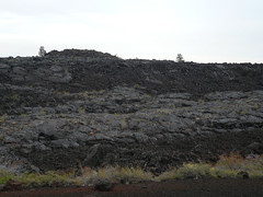 is hotspot over millions of years. This series of caldera formed this Snake River Valley and continued all the way to Yellowstone National Park. After the caldera moved east, this portion of the snake River Valley was subject to multiple volcanic eruptions. Some of eruptions spewed lava over earlier eruptions' lava flows. Anyway, the entire landscape looks like what I think the moon would look like. I took a series of pictures (my photographer handed me her camera for the day). I'm not sure they do justice to this unreal landscape but take a look at them anyway.
Driving through the Snake River Valley, the mountains were just off to ou
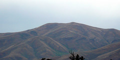 r right. I took a couple of pics, but again, I think the lens inadequate to the canvas. These mountains were unlike anything at home. And they were bare of trees or almost, and covered with dried grass. The ridges stood out in stark relief from the rest of the mountain. You could see the gullies between the ridges and the entire thing was simply striking.
We continued into Oregon, leaving the Snake River Valley behind and picked up the Malheur River. (I think this means bad hour in French -- if so appropriate). This river has cut its way through the mountains above about 4800 feet elevation. We followed the river as closely as many a New England road follows a river through a valley. Because the river cut just about enough room for itself, it was an adventurous drive. (But the mapping company is blamed for this one). The thing I really wanted to value is the absolute beauty of those cuts. The mountains were cut off with sheer cliffs towering above us. Near the top of most of the mountains, was a layer of Cap Rock. It was obviously harder than the layers above and below it so it looked like a crown or the wall of a castle. Just beautiful but unlike anything at home.
The rest of the pics are here.
I noticed that there are bales of rocks in the fences here. Bales of rock in wire like chicken wire that I've seen as retaining walls in New England. Here they are used to support fences where all the posts are just driven metal rods. These bales act as anchors at corners and at cattle gates (pipes laid across an opening that cattle and horses will not cross).
We followed a road across the middle (North South axis) which goes through an area called high desert. Dry, cracked ground growing Sagebrush. Cattle few and far between and irrigated fields ever further between. We reached Bend OR (central OR) and turned South. Suddenly we were in the beginnings of cedar trees everywhere. Soon the cedars gave way to fir. Wow. Sudden change in miles!
Tuesday, September 4, 2007
Chat II
To bring you up to date on my wanderings, here's another chat.
We left West Yellowstone Montana and proceeded on Route 20 West into Idaho we continued on her 20 down to a South to a town called Ashton where we left this main road and picked up state Route 32 which led us to state Route 33 in the towns of Tetonia, Driggs, and Victor. Our directions provided by DeLorme software had us make a U-turn in Victor and follow state Route 33 North back to US 20. I, of course, can read a map better than DeLorme. I could see that state route 31 off 33 would lead us to US 26 and across to US 20. So the driver followed my directions and we went over a mountain on State Route 31 where truck warning signs were posted. At one point we saw a 7% downgrade ahead. The next sign showed a series of curves and the speed posted on the serpentine sign was 60, yes, Sixty. Mike managed to hold the RV on the road at 50. Needless to say, we did not set any miles per gallon records on this trip.
We traveled on Route 20 through Idaho Falls and awe in through Butte city to a town called Arco. In Arco we were right on the page of the mountains we later learned that except for this southern section called the snake River Valley or region, Idaho is mountains. In Arco, the mountains come right to the edge of town and high school tradition requires that each graduating class painted of their year and number on the rocks on this nearest mountain the tradition has been going on since 1927. I kind of liked it. We debated how often the number has to be repainted and who does it particularly for the class of 1927 and its near numbers. I decided grandchildren did the repainting! We left Arco and followed Route 20 to Mountain Home, Idaho. All along Route 20, the mountains remained just to our north. Near the end of this route, we suddenly had to cross the mountains to our south. This time it was DeLorme's fault.
My son Erik observed that we must have Calamity Jane on board this bus. As he was hearing from me about places we had left, he noticed the news consistently reported calamities there. For instance, we left Wisconsin and they were inundated with floods. We left Fairmont Minnesota in the rain and it rained there for a week. One day they got something like 8 inches. More floods. The day we left Bozeman Montana, there was a gas main explosion and fire in the city with great damage. A couple of days ago, we decided we'd go to Sisters Oregon to stay a few days and rest up from our arduous journey. Peggy called to make a reservation and was told there was no room at the inn! Tonight, just before dinner, I turned on the TV for local news and found there is a major forest fire out of control just outside of Sisters. Now I don't want to claim either Calamity Jane type powers or the ability to project a revenge on people, but I think people should be warned about us. Don't you?
My daughter, Melissa, came through with info about Lodgepole Pine. It seems growth depends on the soil but it is reasonable to assume that the 10 foot trees I saw were indeed about 20 years old. Live and learn.
As we got on the interstate this morning from Mountain Home, we discovered the street we'd been following for about 4 miles simply ended as an entrance ramp onto the interstate. That reminded us of the peculiar entrance and exit at Medora, North Dakota. Going west, you can exit at the Medora ramp but you can only get on again going west after passing through the town. It's the same going east. That town is set up to get the tourist dollar.
We saw a sign saying welcome to the high desert country while we were in Idaho. I have never seen so much irrigation as we saw there. There was great circle irrigation where the water is pumped through a pivot in the center of the circle. The irrigation lines are carried on wheels in arcs between each wheel, sometimes very far -- I would say 100 yards to 300 yards. Another type of irrigation is the wagon wheel type. The pipes are connected through the center, the hub, of a series of wagon wheels spread out in a line across the field. Spray holes in the pipes irrigate the fields. Another type is 20 inch wheels supporting poles and the water is dispensed from the arcs running between poles in a straight line across the field. Instead of spray holes, these arcs have hanging hoses with a spray type nozzle in the end every foot or so spraying water on the field. When we crossed into Oregon, I thought we had left irrigation behind because there were no machines like those described above in the fields. However, the truth soon dawned. The need for irrigation is just a strong in that part of Oregon touching Idaho but there is a difference. If you look at a map of the Eastern Oregon, you'll find a series of tiny blue squiggly lines all over the map. Rivers, brooks, streams of all sorts draining eastward from the mountains. The farmers of this section of Oregon have set up canals to tap the water from the streams and bring it miles, in some cases, to the fields where it is sent through these cement channels six to 12 inches wide along the edge of the field. Dipping into these channels are hoses which lead the water from the channel down the rows in the fields like a soaker hose. I have seen corn, onions, alfalfa, soybeans, hay fields and pastures being irrigated in south eastern Oregon. I never expected, in my life, to see hayfields and pastures irrigated. By the way, I saw two large dairy farms northwest of Boise Idaho. These are the first dairy farms I have seen since Wisconsin or maybe Eastern Minnesota.
Snow fences here in Oregon have a new twist. They are made of aluminum and the horizontal "boards" are like the old tin or aluminum corduroy roofing. Another new thing in Oregon: Farmers have pole barns setup to move the hay undercover. This is the first sign I've seen of hay being protected, and not left as bails in the field. Maybe it's because this is hay grown on irrigated fields. That must make it much more expensive.
Now I need more help. We have seen a great deal of a tree type which looks a lot like a white birch but isn't quite. Any ideas of what this look alike is?
Monday, September 3, 2007
Yellowstone and Tetons
It's hard to believe that I am so far west that we went east to enter Yellowstone Park. We camped in the little town called West Yellowstone Montana. The West Park gate is a quarter mile from the town. We toured the south part of the Park the first day where I saw elk and for the first time. I saw elk and a couple of times more. Each time it was a herd of females with calves eating grass near the road and a buck hiding right on the edge of the forest. I couldn't decide if he was there for his own protection over that of his harem. I also saw Buffalo alone, in small groups of two or three, and in herds. I saw them beside the road, across the field, walking along the road and walking down the center of the road. I get to the point where I'd rather not see them because, inevitably, some tourist would stop dead in the middle of the road to gawk. traffic in both directions would stop dead and we have to wait until the gawkers in all the cars in front of us had seen their fill. An interesting observation is that all the single and small-group buffalo were male. When I saw herds, they were clearly mixed groups of males females and young. What is the social pattern of Buffalo? Does anybody know?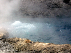
I found it interesting to see steam rising in what seemed to be just the fields. Then we saw a bubbling pots, not quite the fountains with with lots of steam. Then I saw Old Faithful! It was everything my imagination said it was going to be. After that, I really lost interest in geysers. However, the very last thing I saw in Yellowstone Park was Beryl Spring, the most amazing blue (Beryl for the stone) bubbling spring. (See pic at right)
The most outstanding feature of this Park, for me, was the Grand Canyon of the Yellowstone River. It was not very wide but it was very deep. The colors of the rock were outstanding in the gorge through which the river flowed. In fact, I decided that this is where the Yellowstone River, Lake and Park get their name. I thought this Park was about geysers. In fact, that's all the introductory video talked about. I was totally taken by surprise on the second day when we walked onto the viewing platform for the gorge. I can't pick a favorite picture so you'll have to go the set of pics called Yellowstone and select view as slideshow. There are two falls here in the river, both of which are striking. I also enjoyed Tower falls.
I was impressed by Mammoth Hot Springs with its two years of salt runoff from the Hot Springs. I was disappointed that the springs weren't flowing down over the tiers. I saw both from below and above in the most impressive was out of road that led around the higher springs. on, I had a wonderful experience.
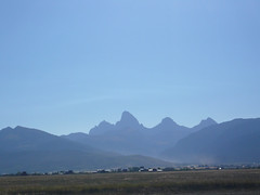
We drove down the Idaho side of the Grand Teton's this morning. With the mountains to our east, Peggy did a fantastic job capturing the dark outline of the mountains against the brightness of the sky (see pic at right). As this mountain chain came into view, it was misty, smoky, looming against the eastern sky. I was reminded so much of the great Smokies near Melissa's home in North Carolina.
As always, I think about the land of the crops. While in Yellowstone, I saw a lodge pole pine everywhere. Something like 80 to 85% of the growth in the park is this pine. The name is very descriptive; it is all pinched right and mostly about six to 10 inches in diameter. Perfect for Indian lodges. However this tree has a peculiarity. Its seeds, only open as result of fire. Therefore, after a forest fire, the trees are self seeking an entire new forest grows up at the same time and therefore the new force is about the same size no matter where you look. This is what intrigues me. Several times we went by signs telling you they hear of the forest fire which burned that section of Yellowstone. These areas were covered with new growth, of a uniform height, interspersed with the trunks of some of the old trees still standing well above the new growth. One sign said forest fire in 1987 which meant that the new growth was 20 years old. This new growth forest was composed of trees not more than 10 feet tall (might have been seven to 10). Does it seem reasonable to you that tree is growing for 20 years would've reached only this height when they reach 30 feet or more when mature. Of course, I cannot find how long they must grow to reach that height. Can anybody help me?
As we drove across Idaho, I was struck by the fields of wheat and maybe potatoes. The land was rolling up the planted fields went up and over and down these hills. A little bit later we started driving up this paper, longer hills on two plateaus where the fields suddenly became irrigated, growing the same crops. The size of grain silos or elevators increased as to their number. Then we drove further up, to a higher plateau, where suddenly the land seemed worthless. We went miles without spotting any sign of human habitation. Off in the distance we started seeing mountains and after some time, we got near enough to see they were barren except for a few scattered trees. They were sharply ridged as if from erosion. None of the three of us would ever agree to live in this area.
I found it interesting to see steam rising in what seemed to be just the fields. Then we saw a bubbling pots, not quite the fountains with with lots of steam. Then I saw Old Faithful! It was everything my imagination said it was going to be. After that, I really lost interest in geysers. However, the very last thing I saw in Yellowstone Park was Beryl Spring, the most amazing blue (Beryl for the stone) bubbling spring. (See pic at right)
The most outstanding feature of this Park, for me, was the Grand Canyon of the Yellowstone River. It was not very wide but it was very deep. The colors of the rock were outstanding in the gorge through which the river flowed. In fact, I decided that this is where the Yellowstone River, Lake and Park get their name. I thought this Park was about geysers. In fact, that's all the introductory video talked about. I was totally taken by surprise on the second day when we walked onto the viewing platform for the gorge. I can't pick a favorite picture so you'll have to go the set of pics called Yellowstone and select view as slideshow. There are two falls here in the river, both of which are striking. I also enjoyed Tower falls.
I was impressed by Mammoth Hot Springs with its two years of salt runoff from the Hot Springs. I was disappointed that the springs weren't flowing down over the tiers. I saw both from below and above in the most impressive was out of road that led around the higher springs. on, I had a wonderful experience.
We drove down the Idaho side of the Grand Teton's this morning. With the mountains to our east, Peggy did a fantastic job capturing the dark outline of the mountains against the brightness of the sky (see pic at right). As this mountain chain came into view, it was misty, smoky, looming against the eastern sky. I was reminded so much of the great Smokies near Melissa's home in North Carolina.
As always, I think about the land of the crops. While in Yellowstone, I saw a lodge pole pine everywhere. Something like 80 to 85% of the growth in the park is this pine. The name is very descriptive; it is all pinched right and mostly about six to 10 inches in diameter. Perfect for Indian lodges. However this tree has a peculiarity. Its seeds, only open as result of fire. Therefore, after a forest fire, the trees are self seeking an entire new forest grows up at the same time and therefore the new force is about the same size no matter where you look. This is what intrigues me. Several times we went by signs telling you they hear of the forest fire which burned that section of Yellowstone. These areas were covered with new growth, of a uniform height, interspersed with the trunks of some of the old trees still standing well above the new growth. One sign said forest fire in 1987 which meant that the new growth was 20 years old. This new growth forest was composed of trees not more than 10 feet tall (might have been seven to 10). Does it seem reasonable to you that tree is growing for 20 years would've reached only this height when they reach 30 feet or more when mature. Of course, I cannot find how long they must grow to reach that height. Can anybody help me?
As we drove across Idaho, I was struck by the fields of wheat and maybe potatoes. The land was rolling up the planted fields went up and over and down these hills. A little bit later we started driving up this paper, longer hills on two plateaus where the fields suddenly became irrigated, growing the same crops. The size of grain silos or elevators increased as to their number. Then we drove further up, to a higher plateau, where suddenly the land seemed worthless. We went miles without spotting any sign of human habitation. Off in the distance we started seeing mountains and after some time, we got near enough to see they were barren except for a few scattered trees. They were sharply ridged as if from erosion. None of the three of us would ever agree to live in this area.
Subscribe to:
Comments (Atom)