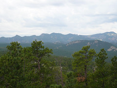
 uriosity to ask why they were called the Black Hills. Now there is a little story behind this question. As we entered South Dakota from Minnesota, I saw hills to the north of Interstate 90 with a black streak running through them. That black streak was probably 50 feet high and ran for half a mile. I asked Peggy and Mike, if that is what the Black Hills looked like. They said no. Now that I've seen the Black Hills, I'm pretty sure that what I was seeing was black rock exposed in the construction of Interstate 90. Or maybe it was the vein of coal? The story of the name of the Black Hills as told by natives is when settlers, explorers, arrived at the hills after crossing the barren prairie, the fir covered hills looked black. (see pic at right)
We began the day by traveling south on the Iron Mountain Road. this route goes through part of Custer State Park, where we spent the rest of the day. As we traveled on this torturous hairpin turn road, the huge granite outcroppings, ledges and bolders made me think of Smugglers Notch in Vermont. The road twists and turns around mountains (Hills) which squeeze the traveler from both right and left. Th
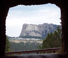 ere were a number of bridges involved in those hairpin turns. They were quite odd. They were called pigtail bridges and were constructed from logs in the form of a three large arches which turn so they weren't in a row. We went through one of the arches on the road, swung around a sharp curve and up over the bridge, turning as we went. Interesting. There were three tunnels carved out of the mountains on this road. After passing through each tunnel, we stopped and looked back at a perfectly framed picture of Mount Rushmore (see pic at right).
Next we took the wildlife loop through the southern half of Custer State Park, where I saw my first wild buffalo (bison) herd. I saw them dotted over a far field, and then on the road in front of us. Shortly thereafter, I saw my first pronghorn antelope. Several times on the loop, we saw wild burros, which are not native to the region, but were released from a tourist trap that failed many years ago. This entire wildlife loop was composed of valleys and dry gullies. The land was not good for agriculture. It was dry and had a lot of stone in it and it was obvious that it had very little rainfall. What rainfall it did have came in heavy rain storms which washed through the gullies and into what I saw as dry streams. In fact, we had heard on TV that there was flooding in the Black Hills just a week prior to our arrival here. I saw evidence of this flooding in a number of the valleys in this park. Lots of tree branches, tree stumps with roots attached, and clay.
I need to take a little detour from the travel narrative here. When I was in the Southwest, I learned, discovered, and that the beauty of the landscape there was really due to massive erosion. Now that I'm in southwestern South Dakota, I can see that the beauty of the landscape here is also due to massive erosion. In the Badlands, you can see the results of years, millennia of erosion. You see the gullies, where the water erosion continues to this day. Here in the Black Hills, you can see much of the same problem. Only here, I think it is earlier in the progression. Major erosion has already taken place here in the Black Hills, but the result is to expose massive slabs of granite which underlies the soil in this area. In Custer State Park, I also saw eroded sandstone, which in some cases appeared to be attached to the granite, like it had been melted together. Today, we were riding north into Rapid City (the second largest city of South Dakota) to do a little shopping, and we started down a hill from a high flat prairie area and I saw in front of me red sandstone or just red soil showing on the grassy hillsides. I suddenly realized that this valley we were driving into was just as eroded as anything I've seen in Custer State Park or even in large parts of the Badlands. The only difference was
 this valley was lightly coated with scrub grasses. In many places the hillsides are so steep that it is naturally terraced, sort of corduroyed. Anyway, I'm shocked again by the awful beauty of destruction.
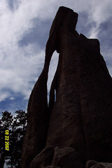
The last part of our trip was along Needles Highway. This was a great deal like the iron Mountain Road, but the switchbacks were sharper and there were a lot more of them. And we were going down steep hillsides with deep ravines alongside. Again, there were three tunnels, but no views of Mount Rushmore. We did stop after a tunnel to view the natural eye of the needle cut into the rock by erosion (see pic at right).
More pics here.
1 comment:
Excellent blog. They're actually called the Black Hills because ponderosa pine needles direct light downward, and so from a distance the hills appear to be black.
shawn
www.blackhillstravelblog.com
Post a Comment