
The Snake River Valley in Idaho is a broad smile shaped valley crossing most of southern Idaho. Just north of the Valley, the mountains of Idaho begin. Where we camped, the mountains were called the Lost River Range. A Ranger told me they were the highest mountain range in Idaho and were primarily composed of limestone. The Sawtooth Mountains are north and west of this. That is where the famous ski resorts of Idaho are located, such as Sun Valley. Anyway, located in this valley is a national park called Craters of the Moon.
A caldera is a ring of rock surrounding a blowout of the Earth's crust. It is far larger than a volcano but leaves the Earth's crust thin and weak and therefore subject to volcanoes. Apparently, a series of caldera were formed starting in western Oregon and continuing every million or so years to the East. In actuality, the location of a hotspot where magma was pushing up toward the surface remained stationary. The tectonic plate actually moved west over th
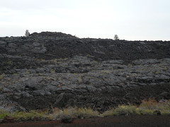 is hotspot over millions of years. This series of caldera formed this Snake River Valley and continued all the way to Yellowstone National Park. After the caldera moved east, this portion of the snake River Valley was subject to multiple volcanic eruptions. Some of eruptions spewed lava over earlier eruptions' lava flows. Anyway, the entire landscape looks like what I think the moon would look like. I took a series of pictures (my photographer handed me her camera for the day). I'm not sure they do justice to this unreal landscape but take a look at them anyway.
Driving through the Snake River Valley, the mountains were just off to ou
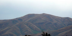 r right. I took a couple of pics, but again, I think the lens inadequate to the canvas. These mountains were unlike anything at home. And they were bare of trees or almost, and covered with dried grass. The ridges stood out in stark relief from the rest of the mountain. You could see the gullies between the ridges and the entire thing was simply striking.
We continued into Oregon, leaving the Snake River Valley behind and picked up the Malheur River. (I think this means bad hour in French -- if so appropriate). This river has cut its way through the mountains above about 4800 feet elevation. We followed the river as closely as many a New England road follows a river through a valley. Because the river cut just about enough room for itself, it was an adventurous drive. (But the mapping company is blamed for this one). The thing I really wanted to value is the absolute beauty of those cuts. The mountains were cut off with sheer cliffs towering above us. Near the top of most of the mountains, was a layer of Cap Rock. It was obviously harder than the layers above and below it so it looked like a crown or the wall of a castle. Just beautiful but unlike anything at home.
The rest of the pics are here.
I noticed that there are bales of rocks in the fences here. Bales of rock in wire like chicken wire that I've seen as retaining walls in New England. Here they are used to support fences where all the posts are just driven metal rods. These bales act as anchors at corners and at cattle gates (pipes laid across an opening that cattle and horses will not cross).
We followed a road across the middle (North South axis) which goes through an area called high desert. Dry, cracked ground growing Sagebrush. Cattle few and far between and irrigated fields ever further between. We reached Bend OR (central OR) and turned South. Suddenly we were in the beginnings of cedar trees everywhere. Soon the cedars gave way to fir. Wow. Sudden change in miles!
No comments:
Post a Comment