
We spent a couple of days at Diamond Lake while we visited Crater Lake. I got up the last morning feeling happy as a lark. Mike and Peggy each noticed it. I, of course, could feel it. I've been debating whether the "high" was due to my experience the previous day at Crater Lake or was it due to the fact that I knew I'd be in California in a few hours? Honestly, California has been a dream of mine for such a long time, I really doubted I would ever get here. Anyway, I was on top of the world.
We proceeded down Route 97, through Klamath Falls and on to the border, leaving Oregon behind. I saw, on the Klamath River, a couple of big squares of logs floating down the river. Somehow, I think these are called booms. They are a large rectangle of logs hooked together with what look like chains, and the rectangle is filled with loose logs. The only thing missing from the scene was lumberjacks skipping from log to log.
We entered California still a 97, which is approximately in the middle of the state, East-West. Within a couple of miles, we passed over a good-sized hill and there was a wide valley filled with various irrigated crops. Each crop was part of a patchwork of colors and textures. Included in these crops were strawberries, flowering, not ready for picking but with some workers in the fields. Somehow, this perfectly fit my mental image of California. It surprised me. I always thought that I'd identify California with San Francisco or the beaches or something else, but crops, green and getting ready for harvest in the winter, struck me as perfect. I even saw crop- dusting (by a truck) far away across the valley. Strange, the mental images we carry.
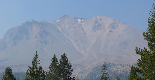
As we were heading toward I- 5, I spotted off in the far distance, the shadow of an outline of a cone shaped mountain. The haze was obscuring a real look. In fact, the sky has remained hazy when looking off in the distance. At home, I think of the three H's, hazy, hot and humid. The last word does not apply here. Hazy, yes. Hot, yes. So hot it set a record for this area and for me.It was 103 at the airport here in Redding California yesterday!!! But back to the mountain. As we continued south, more and more of the haze cleared until, finally, we came around a corner and there, in all its glory, was Mt. Shasta. Huge, snow-covered for at least its upper third, with granite cliffs and ridges showing through the snow. Magnificent.
In my mind, I compared Mt. Shasta to Mt. Washington in New Hampshire.I guess it was the way they both stand out from their surroundings. Anyway Mount Shasta is about 8000 feet higher than Mount Washington, some 14,000 feet versus 6200. So much for comparisons.
Here in Redding, there is a fantastic architectural/engineering marvel. Peggy and Mike had been there and wanted to show me their find. My first glimpse made me think of the new bridge type I've seen in Boston and Savanna. The kind where there is a vertical support and cables running out from each side like harp strings.I was surprised when we got close enough to see the vertical support was leaning in about a 30° angle away from me and the cables stretched only on one side of the vertical. This is a walking bridge and the floo
 r of the bridge is made of glass rectangles. Note the footprints (shoe shadows) in this pic. The bridge is simply a marvel. The off vertical piece balances against the suspended floor of the bridge on a 12 inch bearing. I kept my photographer busy. See the rest of the pics here. By the way, I walked onto the bridge before I realized I was walking on glass. I quickly moved to one of the two granite stripes but Mike was insistent that I walk on glass. He also insisted I touch the first cable I came to. It was vibrating! Needless to say, I touched no others. If you're ever in Redding, you've got to see this.
From the man-made to natures way, we next visited Lassen Volcanic National Park. It is promoted as a combination of Yellowstone and Yosemite. I was very disappointed that we saw no Rangers except the one selling tickets at the gate. I had a lot of questions especially about trees that I was unable to get answered. The visitors center was closed and locked. So I'll tell you about the Park and leave you with questions I can't answer.
Prior to Mount St. Helens, Lassen was the last volcano to erupt in California, in 1915
 . In the picture to the right, the mountain erupted just below the center peak. Eruption blew away rock which had formed in an earlier eruption 27,000 years ago. It was a reddish hue. Multi ton rocks were carried by snow avalanches as much as 5 miles from the eruption. No one was killed but all homes in the valley were wiped out. We saw a great deal of evidence of the older rock but very little of the new rock which formed in this eruption. In the picture, the caprock on the left of the picture is of the same color as the old reddish rock.
Further into the Park we found a caldera with a small dome shaped peak in the middle. The caldera was similar to Crater Lake's but incomplete in that it was not a complete circle. Having seen Crater Lake, it was easy to piece together the parts of the caldera still showing here. It is what is left of a mountain called Brokeoff Volcano, which was the same size as Lassen before it erupted. Also in the Park we saw some fumeroles (steam vents), some boiling water pots and some sulfur spots. Not as impressive as Yellowstone but of the same type and origin. No geysers, however.
Now, trees. Lassen is an evergreen forest. The park rises from around 1000 feet altitude to over 10,000 feet at the top of Lassen Peak. We exceeded 8000. A little funny. As we were climbing up toward the high point of the road in the park, Mike and Peggy kept hearing something. As we reached about 8000 feet, there was a loud bang. Peggy was sitting in the backseat and said WOW! Mike and I both jumped. Peggy found that our unopened Lays potato chip bag had burst open alo
 ng the top seam. It seems that Lays guarantees freshness only below 8000 feet.
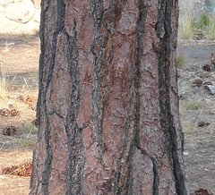
Trees, that's where I was. The pic at right is of a large pine near the entrance of the park. I was particularly impressed by the pattern in the bark. The black lines are recessed and the bark has a strong three-dimensional character. In the leaflet we got at the gate, the Park service says there are Jeffrey Pines near this point. Before I read that, I was convinced these were Ponderosa Pines, based on the bark and the large pine cones lying at their base. HELP!
There were also a number of other trees which intrigued me, They were growing at various altitudes. One was a ladder-like tree. The branches seem to grow in perfect steps and exactly balanced left and right. HELP!
Then there were the trees that looked like their bark had been shredded. The bark of the tree looked stringy. I thought of Cedar but my experience with Cedar is limited to 10 or 15 foot tall trees. Of these were double or triple that.
Then I started examining the needles on these evergreens whenever we stopped. Some sort of reminded me of hemlock. The branches were flat and the twigs at the end of th
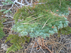 e branches spread out with short needles on each side of the twig. Another shown in this pic, made me think of Blue Spruce except only the end (new) needles were bluish and the needles were soft rather than spiky. HELP!
There, that should be enough questions. The rest of the pics are here.
No comments:
Post a Comment